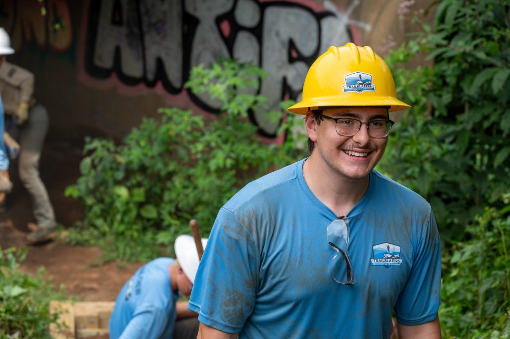
Shenandoah National Park's pilot Trailblazers program gets kids into conservation. Photo by Stephen Barling.
On the last Monday in July, in the fields behind the Fifth Street Starbucks, a crew of sweaty high school kids is taking a mid-morning break, swigging energy water and snarfing down bags of chips (after working outside all morning, they need the salt). Their blue T-shirts say “Trailblazers.” And that’s what they are—pioneers in a pilot program to get local youth acquainted with the outdoors and maybe introduce them to careers in conservation. An added bonus: These kids are earning a paycheck while providing much-needed maintenance on the popular Rivanna Trail encircling Charlottesville.
The Trailblazers: Charlottesville to Shenandoah program is one of those genius ideas that seem obvious—once everyone has done the work to make it happen. But it took four local organizations, two city programs, a local retailer, and a national nonprofit working together to make the idea into a reality.
The lead organization on the Trailblazers program is the Shenandoah National Park Trust, which runs a trail maintenance program called the Shenandoah Youth Corps, designed to provide young people with work experience in conservation. The Appalachian Conservation Corps has partnered with SNPT on the Youth Corps program for the last six years, providing experienced adult leaders for the youth trail crews and handling logistics.
Photo by Stephen Barling.
Tommy Safranek, a Rivanna Trails Foundation volunteer who had previous experience as a youth trail crew leader, had applied for a grant from outdoor retailer Public Lands in hopes of starting such a program here—right before the city hired him as its bike and pedestrian coordinator. Safranek is also on the board of the RTF, which is always looking for ways to get the community involved in both using and caring for the Trail—as is the Charlottesville Area Mountain Bike Club, whose members also use and help maintain the Trail.
“We’d been having conversations with Zach Foster [ACC’s executive director] about how to go about diversifying the Shenandoah Youth Corps, so that was fresh in my mind when I ran into Tommy Safranek one night while he was out walking his dog,” recalls Ethan Serr, SNPT’s corporate and foundations development manager. “We started talking about our different organizations and found a shared challenge in the need to diversify trail usage. He had mentioned that they were exploring the idea of a youth trail crew for the Rivanna Trail, which got me thinking about how we could collaborate as a means of developing a pipeline for more diverse participation in the Shenandoah Youth Corps. I pitched the idea to the Trust’s executive director and the director of partnerships, and they of course were interested and took the lead from there.”
Last August, SNPT and ACC met with RTF to discuss building a paid youth corps program in the Charlottesville area. SNPT was willing to act as lead, but the other organizations contributed as well, with added financial support from Safranek’s Public Lands grant and funding from the Virginia Outdoors Foundation.
It made sense that the adults managing the youth crew would be hired from the ACC staff. “We’re in charge of actual implementation,” explains Foster, “because we have [the Youth Corps] experience at managing the work. We handle the transportation, the risk management, and have the crew leaders who provide mentorship. But CAYIP was really the key because they can recruit the participants.”
CAYIP—the city’s Community Attention Youth Internship Program—finds local retailers and organizations willing to provide Charlottesville youth with paid summer internship programs that widen their experience and help them develop career skills. Latara Ragland, interim CAYIP coordinator, says, “We became highly interested and truly excited about the program. CAYIP is always looking for site partners that are conducive to mentoring young people while they receive a hands-on work experience. [Trailblazers] made it even more exciting because of the commitment and dedication all these agencies were already investing in our community and young people.”
This spring, CAYIP added Trailblazers to the youth internship recruitment efforts it runs every year in Charlottesville schools. Applicants for Trailblazers had to be city residents aged 16 to 18. Participants are expected to work up to 20 hours a week for the six-week session and will earn a performance-based stipend of up to $15 per hour (not to exceed $1,800). They are also expected to build a resume at the end of their internship.
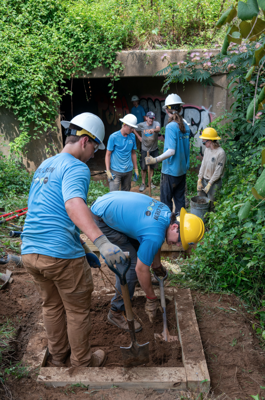
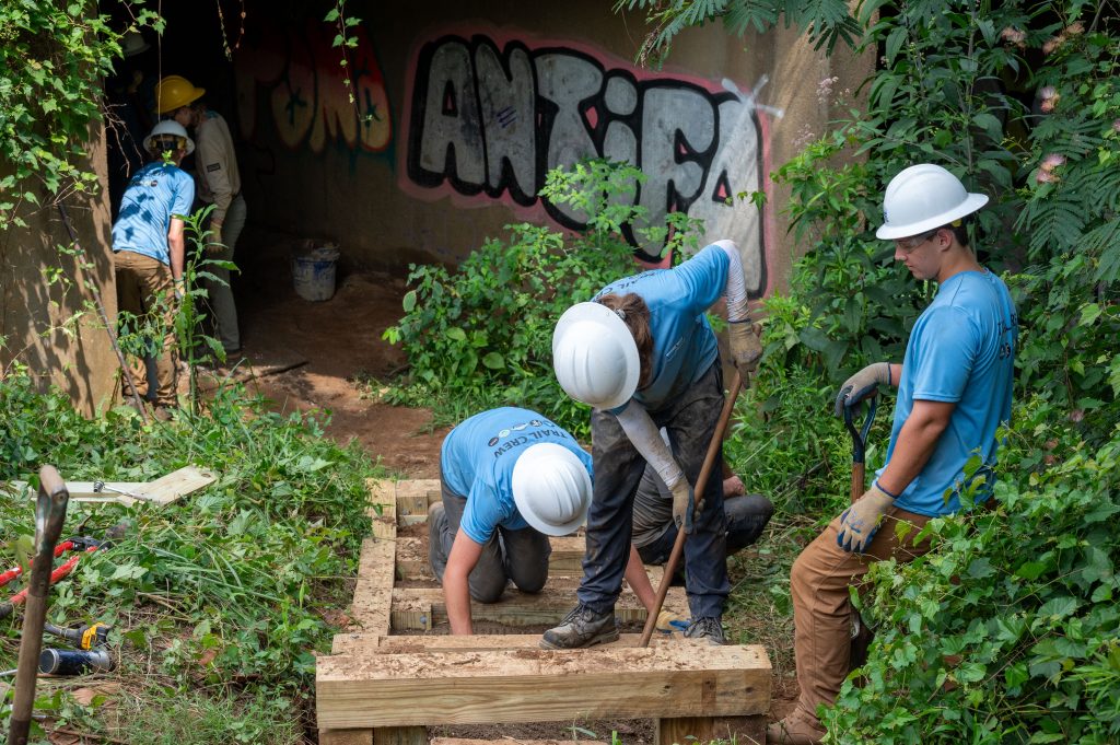
On a Monday in July, five of the program’s eight interns were working on installing a series of steps where the Rivanna Trail heads into an underpass below Fifth Street. Photo by Stephen Barling.
Trailblazers team lead Emma Callan of ACC says the eight interns spent their first day in the field learning how to use the tools of trail maintenance. Each day starts with a “stretch-and-safety circle,” not just to get ready for hard physical work, but to reinforce safe practices “and remind everyone to stay hydrated.” After seven weeks of trail work, the program ends with an intensive three-day camping and trail maintenance project in Shenandoah National Park—a new experience for most of these young people.
On the day I visit, Callan and her colleague Jon Rice have a crew of five—Wes Swanson, Jamond Johnson, Eagan Matthews-Huba, Matthias Zimmerman, and Will Wright—working on installing a series of steps where the trail heads down into an underpass below Fifth Street between the Starbucks and the former Christian Aid property. (Other crew members Christian Martinez, Nava Khurgel, and Nick Brown are out today.)
“Some of these kids are active outdoors—they do sports, some have used the trail,” says Callan. “But they are mostly trail newbies in terms of manual labor.” I arrive during their late morning break (hence the drinks and snacks); the boys are sweaty but good-humored and put their hard hats back on cheerfully when work resumes.
Overseeing construction is Tim Pare, a retired engineer and longtime RTF volunteer. “The trail was being eroded here,” he points out. “This is low ground that gets flooded and gravel would wash away, so we’re cutting in steps, framing them out with lumber, and filling in with a combination of gravel and concrete called lean mix.” (The trail intersects a section of sewage lines at this point, so the Albemarle County Service Authority donated the materials for these steps.)
Photo by Stephen Barling.
In comments provided by ACC, Swanson said he found out about the program through his school’s career fair. “It’s really cool learning how the trails are designed and learning how to make it the right angle so the water flows off it in the right way. It’s also really fun using all the machinery. I definitely want to find a way to work in conservation after this experience. Maybe I could do it every summer during college. I would love to have a career related to this.”
Similarly, Zimmerman, a CHS senior, said, “I’ve always been around the Rivanna River and live right near the trail, so it’s awesome to be making this area even better. I’m learning more skills so I can really use what I have learned to better my community. I was definitely thinking about going into forestry as a career—or something with outdoor nonprofits in the future.”
As this year’s pilot program is wrapping up, the consensus is that Trailblazers has been a success all around. “We are so proud of the interns—all eight successfully completed this session,” says Ragland. “Their feedback has been consistent: They have truly enjoyed the experience.” In fact, she notes, “We had more students interested in the program than we could accept this year, and we hope this interest grows in the future as more teens learn about it.”
“The crew is putting in really solid work, and the kids are getting real skills working with RTF and CAMBC,” says Lauren Croissant, ACC youth program coordinator. That’s good news for ACC and SNPT as well, since these organizations hope the Trailblazers internship will lead a more diverse group of young people into programs like the Youth Corps and help the Park build relationships and encourage interaction with surrounding communities. In fact, Serr says SNPT has had interest in programs similar to the one in Charlottesville from Richmond, Harrisonburg, and Washington, D.C.
Photo by Stephen Barling.
In a Trailblazers press release, Bobby Casteen, a CAMBC board member, calls Trailblazers an important initiative “because it promotes collaboration between community organizations to create change, and it can influence youth to see the value in community engagement and service.”
Safranek sees awareness of the city’s natural resources as another of the key goals of the Trailblazers program. “As the city’s bike and pedestrian coordinator, my job is to get more folks in our community walking and biking,” he says. “Sometimes that means building more sidewalks and bike paths, but this program allows our youth to discover the amazing trail resources that we have right here in Charlottesville. So, my hope is that they not only make our community more friendly to walk and bike, but they also now choose to bike or walk next time they need to get around town.”
For Callan, one of the rewards for the Trailblazers interns is the sense of accomplishment and community pride it gives them. “Once these steps are done—or any of our projects they worked on—they can come back to the trail and show their families and friends, ‘Hey look, I built that!’”
A congregant reacts during an Easter Sunday mass at Covenant Church on Sunday, April 12, 2020. Churches have adapted to allow patrons to listen to the services from their car radios and over loud speakers in order to continue congregating. PC: Zack Wajsgras
Creative worship in the age of corona
Pastor Harold Bare was met with an unusual scene when he stood in front of his congregation on Easter Sunday—a barrage of car horns during a Facebook-streamed drive-in service, which welcomed congregants to decorate their vehicles and watch Bare’s sermon from a parking lot.
Like every other institution in town, religious organizations have had to get creative as the novel coronavirus has radically reshaped our world. On Good Friday, Bare’s Covenant Church convened its choir over Zoom, with singers crooning into laptop microphones in rough, tinny unison.
“Fear not, God is in control,” read a sticker on the side of one car at Covenant’s Easter service. Additional stickers thanked more earthly leaders, like nurses and doctors.
Other religious groups have had to adjust in similar ways. Zoe Ziff, a UVA student, organized a Zoom Passover Seder for her friends who have been scattered across the world by the university’s closure.
“We spoke over each other and lagged, but it was beautiful to see my friends, hear their voices, and share the story of Passover together,” Ziff says. “It’s a reminder that everywhere in the world, Jewish people are retelling this story—though this year, over a webcam.”
“We’re being as careful as we know how to be,” Bare said at the beginning of his holiday sermon. Religious traditions might stretch back thousands of years, but these days, they’re Zooming along just like the rest of us.
A congregant’s car is seen decorated during an Easter Sunday mass at Covenant Church on Sunday, April 12, 2020. PC: Zack Wajsgras
______________________
Signing day
The Virginia legislature turned in a historic session earlier this year, and as the deadline approached this week, Governor Northam put his signature on dozens of new bills. The new laws will tighten gun safety regulations, decriminalize marijuana, allow easier access to abortion, make election day a national holiday, repeal voter ID laws, allow racist monuments to be removed, and more. Northam didn’t sign everything, though—he used his power to delay the legislature’s proposed minimum wage increase by one year, citing the effects of the COVID-19 pandemic.
______________________
Local COVID-19 case update
53 confirmed cases in Albemarle
34 confirmed cases in Charlottesville
4 deaths
Data as of 4/13/20, courtesy of Thomas Jefferson Health District
______________________
Quote of the Week
“In Virginia, the capital of the Confederacy… in Charlottesville, the home of Thomas Jefferson… We led the charge to change the state. It’s all been worth it.”
—Former vice mayor Wes Bellamy, on the new law allowing localities to remove Confederate monuments
______________________
In Brief
Statue status
Governor Ralph Northam has finally made it official: Charlottesville will soon be able to legally take down its Confederate monuments. The bill, which Northam signed on April 11, will go into effect July 1. The end is in sight, but the city will have to wait 60 days and hold one public hearing before the statues can be removed.
Foy joy?
Last week, state Delegate Jennifer Carroll Foy (D-Prince William) filed paperwork to run for Virginia governor in 2021. Foy is a 38-year-old former public defender who sponsored the legislation that led to Virginia’s ratification of the Equal Rights Amendment. If elected, she would become the first black female governor in United States history. Her likely Democratic primary opponents include Lieutenant Governor Justin Fairfax, an accused sex offender, and Attorney General Mark Herring, who has admitted to appearing in blackface.
(No) walk in the park
To the disappointment of Old Rag enthusiasts, the National Park Service completely shut down Shenandoah National Park April 8, per recommendation from the Virginia Department of Health. All trails—including our stretch of the famed Appalachian Trail—are now closed. Still want to explore the park? Visit its website for photo galleries, videos, webcams, and interactive features, or follow it on social media.
Win-win
Under the name Frontline Foods Charlottesville, local organizations are working with chef José Andrés’ World Central Kitchen to deliver food to health care workers, with meals supplied by area restaurants like Pearl Island Catering, Champion Hospitality Group, and Mochiko Cville. In the coming weeks, FFC plans to add more restaurants, which will be reimbursed for 100 percent of the cost of food and labor, and expand to serve other area community members.
Demanding justice
As reports of intimate partner violence increase due to coronavirus lockdowns, UVA Survivors, a student advocacy and support group, has created a petition calling for the “immediate, structural, and transformative change” of the university’s sexual violence prevention and support services. The petition demands UVA fund an external review of the Title IX office; provide survivor-created and informed education on sexual violence and consent; create a stand-alone medical unit for sexual, domestic, and interpersonal violence survivors; and move the Title IX office from O’Neill Hall (located in the middle of UVA’s ‘Frat Row’), among other demands. It has been signed by more than 100 students and student organizations.
TSA agents are being required to work without pay at CHO and at airports around the country.
file photo
Almost one month into the federal government shutdown, Charlottesville hasn’t been hit as hard as Northern Virginia, where thousands of government workers are trying to figure out how to pay their mortgages and buy groceries. But there are more than 200 people here being asked to work without a paycheck, and approximately 4,100 households in the city and county that could see their food stamps run out if the shutdown continues to March 1.
One of the area’s larger employers, the spy center, aka the National Ground Intelligence Center up off U.S. 29 north, is part of the Department of Defense, and its 1,250 staffers won’t be missing a paycheck.
Things are not so rosy for the 40 or so TSA employees at the Charlottesville Albemarle Airport, who are being asked to work without pay. Their salaries range from $25,000 to $38K, according to the TSA website.
“We have been very lucky with the dedicated staff,” says CHO deputy director Jason Burch. “They are showing up. It’s got to be tough.”
Local companies and citizens have been providing sandwiches and pizza for the strapped security agents, says Burch. “Our TSA lines aren’t any longer,” he adds.
There are approximately 10 air traffic controllers—CHO spokesperson Stewart Key says she’s not allowed to say how many—who work for a company contracted by the FAA. Key says the controllers are not affected by the shutdown,.
Over at Shenandoah National Park, around 200 employees are employed this time of year, says Susan Sherman with the Shenandoah National Park Trust. The phone number for the Humpback Rocks Visitor Center on the Blue Ridge Parkway was out of service, and no one answered the phone at the parkway’s headquarters in Asheville.
On January 6, the Department of Interior instructed national parks to tap into recreation fees to clean bathrooms and haul trash—a move some say could be illegal. Volunteers and nonprofit advocacy organizations like the Shenandoah National Park Trust are pitching in.
The trust has picked up two contracts to clean bathrooms at Old Rag and White Oak Canyon, says Sherman, and is sending gift baskets with snacks “to fuel park colleagues who are working without pay.”
Sherman worries about the long-term effects of the shutdown: damage to natural resources, the gap in scientific research and monitoring, the bear population getting used to easy pickings at overflowing trash cans, and the morale of park service employees.
“It’s not uncommon for married couples to both be employed by the park,” she says. “They’re public servants who have devoted their lives to working there, and they’re being told they’re nonessential. That’s inexcusable, in my opinion.”
Also in the shutdown’s crosshairs are families that depend on the Supplemental Nutrition Assistance Program—formerly known as food stamps—which is funded through the USDA, another “nonessential” agency. On January 17, Virginia SNAP recipients received their benefits for February because the USDA is funded through January.
Around 2,000 households in Charlottesville and another 2,100 in Albemarle receive SNAP benefits. Sue Moffett with the city’s Department of Social Services worries about recipients managing money received three weeks early that’s supposed to last through the end of February.
She says anecdotally, she’s seeing new requests for food stamps and for other assistance, such as Temporary Assistance to Needy Families. “I have knowledge of people affected by the federal furlough,” she says.
Michael McKee is CEO of Blue Ridge Area Food Bank, which serves 25 counties in western and central Virginia, including hard-hit Loudoun and Frederick counties, where he estimates around 15,000 furloughed federal employees live.
The food bank serves 106,000 people through its network of food pantries and soup kitchens—on average 14,000 in Charlottesville and Albemarle—and about two-thirds of those receive food stamps. “SNAP provides 12 times as much food as America’s food banks,” he says.
If those benefits aren’t restored by March 1, “We can never begin to make up for what we would lose with SNAP,” says McKee. “We could be completely overwhelmed and unable to meet the needs of our neighbors.”
UVA has myriad ties to federal funding, but because many federal agencies have already been funded for fiscal year 2019, “the impact on UVA right now is isolated and limited,” says spokesperson Anthony de Bruyn. “UVA is monitoring the situation closely and preparing for potential effects if the shutdown continues past this month.”
Thanks to DoD funding, the JAG School at UVA’s School of Law is in operation, according to an officer there.
At the Federal Executive Institute on Emmet Street, people answering the phone refused to say whether the facility is open, and referred calls to the Office of Personnel Management. The OPM confirms the government leadership training center is open, although it’s unclear what essential service it provides.
Meanwhile, the shutdown is even thwarting local breweries that want to introduce new brews. Says Champion Brewery’s Hunter Smith. “We have to get all our labels approved by the Tax and Trade Bureau,” which normally takes two weeks when it’s open. He’d planned to introduce as many as six new beers this year, and had to stop production on one.
So far shuttered government agencies haven’t affected the real estate market, says Nest Realty’s Jim Duncan, but that could change if the closures continue.
“Right now the biggest effect is on the psychology of the consumer,” he says. “It’s hard to quantify fear.”
***
When the government doesn’t take care of its own
A number of businesses and individuals are trying to help out the public servants who are furloughed or working without a paycheck. Great Harvest has taken sandwiches to CHO to feed beleaguered TSA agents, and is offering free sandwiches, salads, and bread to unpaid federal workers.
To help paycheck-less government workers forget about their travails, a couple of movie theaters are offering free flicks. At Alamo, that’s on Monday through Thursday, and Violet Crown is hosting free matinees on those days.
And the home of Founding Father James Madison. Montpelier, is offering free tours to feds and their families, who may be able to catch Madison rolling in his grave.
Correction January 18: Susan Sherman said around 200 employees are at Shenandoah National Park this time of year. She is not privy to how many are nonessential.
Cool off at Blue Hole (pictured) and other local spots this summer. Photo by Tom Daly
By Sashank Sankar
There are three types of people during the summer. The first choose to stay within the comforts of air conditioning. The second like to be outdoors, but not too far from civilization, only venturing to swimming pools and local parks. The third have an adventurous streak. And if you fall within that category, there are plenty of options for cooling off around Charlottesville.
The following swimming holes are tucked into the heart of nature, which means they require a few miles of hiking to reach them. And while the hikes vary in length and difficulty (although they’re all doable for novice hikers), they offer great views of the Blue Ridge Mountains—perfect for your next Instagram post. Plus, after a long hike, the best reward is diving into refreshing water.
Blue Hole
Location: Parking is available at 6796 Sugar Hollow Rd., near the Charlottesville Reservoir. Walk along the trail for about 1.5 miles.
Hiking: 3 miles out-and-back. It is a little steep, so bring enough water and take your time.
Cost: Free
Fun fact: Blue Hole is a common nickname for swimming holes, and this specific spot used to have a rope swing. Unfortunately, the tree that held the rope fell down a few years back, so it isn’t there anymore. But there are plenty of trees to create a new one, if you’re up to the challenge.
Riprap Hollow
Location: Park at the Riprap Trail parking area at milepost 90 on Skyline Drive, in Shenandoah National Park.
Hiking: 9.8-miles round-trip. Recommended for more experienced hikers.
Cost: $15-30
Fun Fact: Although a difficult hike, the swimming hole is located 3.4 miles into the trail, meaning you don’t have to complete the whole thing. More time for swimming!
Paul’s Creek
Location: The trailhead (and parking) is located off Paul’s Creek Court in Nellysford.
Hiking: 1.2 miles round-trip, an easy hike.
Cost: Free
Fun Fact: There are three natural water slides at Paul’s Creek.
White Oak Canyon/Cedar Run Trail
Location: Parking is available in the White Oak Canyon lower parking lot, off Chad Berry Lane, inside Shenandoah National Park.
Hiking: 7.3 miles round-trip. Difficult and recommended for more experienced hikers.
Cost: $15-30
Fun Fact: There are five waterfalls on this trail—perfect for anyone who’s looking for picturesque views as well as a swimming option.
Snake Hole
Location: Parking is available at 6796 Sugar Hollow Rd., adjacent to the Charlottesville Reservoir. It is the second river crossing you come across.
Hiking: 1.6 miles round-trip. A relatively easy hike, although a little steep.
Cost: Free
Fun Fact: This swimming spot is in the same location as Blue Hole, but getting there is an easier hike and a shorter distance. Bonus points if you hit both in one day!
After a long hike, the best reward is diving into refreshing water.
The winners of a contest to memorialize Vinegar Hill proposed an 80-foot wall made of layers of metal maps of the lost neighborhood on the west side of the Downtown Mall.
Vinegar Hill reimagined
The winners of a Bushman Dreyfus Architects and Tom Tom Founders Festival competition to use public spaces to create constructive dialogue and to reimagine Vinegar Hill, the city’s historic and predominantly African-American neighborhood, proposed an 80-foot wall made of layers of metal maps of the lost neighborhood on the west side of the Downtown Mall.
The wall, similar in size to the Freedom of Speech Wall on the opposite side of the mall, would be surrounded by rolling benches. Winning team members Lauren McQuistion, a UVA School of Architecture grad now based in Detroit, A.J. Artemel, director of communications at Yale School of Architecture, and Tyler Whitney, a former junior designer at local VMDO Architects who is also now in Detroit, received a grand prize of $5,000. All three are 2011 UVA graduates.
Thanks to urban renewal, Vinegar Hill was razed in 1964, and the city is currently considering how to memorialize it, independently from the competition, which garnered submissions from 80 applicants across 20 countries.
Quote of the Week: “One of the saddest outcomes of Ryan Kelly’s Pulitzer-winning Charlottesville #photo is he’s leaving #journalism altogether & not returning. He now works for a brewery.” —K. Matthew Dames, an associate librarian for scholarly resources and services at Georgetown University, on Twitter. Kelly had already planned to leave the Daily Progress, and August 12 was his last day.
Crozet triangle
A twin-engine Cessna crashed off Saddle Hollow Road April 15, killing the pilot, not far from where Piedmont Airlines Flight 349 slammed into Bucks Elbow Mountain in 1959 with one of the 27 people onboard surviving. Crozet also was the scene of a GOP congressional delegation-carrying Amtrak crash into a Time Disposal truck that killed one person January 31.
Rain tax quenched
Photo by Richard Fox
Albemarle Board of Supervisors decided April 11 to use its general fund to pay for the stormwater utility fee because of massive farmer outrage. Next issue to get riled about: property taxes going up.
Park entry fees upped again
It’s going to cost five bucks more to visit Shenandoah National Park this summer. Starting June 1, vehicle entrance fees will be $30, motorcycles $25, per person is $15 and an annual pass is $55. Good news for seniors and frequent parkers: The annual pass to all parks and the senior lifetime pass remains $80.
Call to condemn
Activist groups Black Lives Matter and Showing Up for Racial Justice want City Council and the Albemarle supes to approve a resolution written by Frank Dukes that condemns the Confederate battle flag that’s been erected in Louisa near I-64.
Cullop walloped
Things are not looking good for 5th District Democratic candidate Ben Cullop, who scored zero delegates at the April 16 overflow Albemarle Democratic caucus in his home county. Leslie Cockburn received 18 delegates, Andrew Sneathern 13 and R.D. Huffstetler will take eight to the Dem convention May 5 to choose a challenger to U.S. Congressman Tom Garrett.
A capacity crowd packed the Monticello High School gymnasium April 16 to participate in the 5th District Democratic caucus.
Court referendum
The General Assembly passed a law that means if Albemarle wants to move its courts from downtown, voters will have a say.
Power of the press
During the 2017 Virginia Press Association awards ceremony on April 14, C-VILLE nabbedaccolades in 10 categories in the specialty publication division, along with two best in showawards for design and presentation (Bill LeSueur and Max March) and artwork (Barry Bruner).
First place
Design and presentation: Bill LeSueur, Max March
Food writing: Caite White, Samantha Baars, Tami Keaveny, Erin O’Hare, Lisa Provence, Jessica Luck, Erin Scala, Eric Wallace
Illustrations: Barry Bruner
Front page or cover design: Bill LeSueur, Max March, Eze Amos, Jeff Drew
Combination picture and story: Eze Amos, Natalie Krovetz, Lisa Provence, Samantha Baars, Erin O’Hare, Susan Sorensen, Jessica Luck, Jackson Landers, Bill LeSueur
Pictorial photo: Jackson Smith
Second place
In-depth or investigative reporting: Samantha Baars
The National Park Service announced plans to raise entry fees to some of its most popular parks to $70 per carload. This includes the Shenandoah National Park, where the cost is currently $25. Courtesy photo
About 1.4 million nature enthusiasts from near and far flock to the Shenandoah National Park each year, but they may soon be greeted by a different type of hike than they’re seeking—a price hike.
The National Park Service announced plans October 24 to increase entrance fees in 17 of the country’s most visited parks from about $25 to $70 per vehicle. As proposed, the entry pass will be valid for a week.
“The argument has been made that $70 for a week’s pass is still an excellent deal for a family vacation,” says Susan Sherman, the executive director of the Shenandoah National Park Trust. But the SNP is within a day’s drive of millions of people on the East Coast, and as a result, the majority of visitors spend only a day in the park, she says. “We believe that a $70 fee for what many use as a day pass would create a barrier to entry.”
The hefty price increase is intended to make up for an $11 billion backlog of maintenance and infrastructure projects in national parks across the nation. In Shenandoah alone, that number is $76 million.
Some of the local park projects include repairing roads and parking areas, repairing and reconstructing numerous historic stone walls along Skyline Drive, upgrading wastewater treatment plants and water systems across the park and upgrading the electrical system at the Front Royal Entrance Station.
“Placing the burden of repairing our parks on the backs of park visitors is misguided,” says Sherman. The trust is “deeply concerned” that the fee increase “will create economic barriers for thousands of would-be visitors.”
National park supporters are calling for the federal administration, which announced its intention to invest $1 trillion in American infrastructure, to allocate some of those funds to the parks. According to Sherman, for every dollar invested, $10 are pumped back into the national economy.
Senators Mark Warner and Ohio’s Rob Portman introduced the National Park Service Legacy Act last spring, which would establish an annual federal fund to restore park infrastructure. If authorized, it would invest $50 million a year to repair national park infrastructure over the next three years, increasing gradually for the following six years, and eventually peaking at $500 million annually for 20 years.
Says Sherman, “This level of financial commitment…is far superior than an increase in visitor entrance fees.”
Scott Osborne, a fly-fishing guide within the SNP, says he relies on its clean streams, brook trout and daily visitors for the success of his occupation.
“I share the park as a special place with people visiting from far and wide,” he says. “This is one of the greatest joys I have in my job, the ability to expose people to the phenomenal beauty and bounty in my own backyard. …Keep the entrance fee to the Shenandoah affordable and people from all walks of life will be able to enjoy and advocate for our natural world. In these turbulent and unsure times, our public lands need us now more than ever.”
A walk in the park
Grab your hiking boots and your sleeping bag. The Shenandoah National Park is a 300-square-mile destination for hiking, camping, picnicking, horseback riding, fishing, leaf peeping—you name it.
Skyline Drive runs for 105 miles across the entirety of the park, but to access it, you have to enter at one of the SNP’s four gates, which costs $25 per carload.
The gate nearest Charlottesville is the Rockfish Gap entryway, which is also the northern entrance to the Blue Ridge Parkway. It’s accessible via Interstate-64 and Route 250.
Five seasonal campgrounds include Big Meadows, Lewis Mountain, Matthews Arm, Dundo and Loft Mountain, with Big Meadows being the first to open in late March and prices ranging from $15 to $20 per night.
The National Park Service announced plans to raise the entry fee in several of America’s most popular national parks to $70. This includes the Shenandoah National Park, where visitors are used to paying just $25.
Big Meadows is the first campsite to open in early spring. It costs $20 per night to say there. Courtesy of SNP
Get your sweat on during a 5K and then jump into a pool party, all for the Ishan Gala Foundation, which supports families of children who have cancer. Free-$45, 7:30-11am. ACAC, 200 Four Seasons Drive. 234-4644.
FAMILY
National Dog Day
Saturday, August 26
Bring on puppy cuddles for the family, with glasses of vino for adults. Live music from guitarists Robin Tolley and Gene Temple, and special treats for four-legged family members. Free admission, 2-4pm. Democracy Vineyards, 585 Mountain Cove Rd., Lovingston. 263-8463.
FOOD & DRINK
Food and wine pairing
Saturday, August 26 and Sunday, August 27
In-depth tastings of current wines paired with a seasonal menu of farm-fresh gourmet small plates. Limit 10 per session; RSVP required. $39, 1pm. DuCard Vineyards, 40 Gibson Hollow Ln., Etlan. (540) 923-4206.
HEALTH & WELLNESS
Fee Free Day
Friday, August 25
Celebrate the National Park Service’s 100th birthday with free entry into Shenandoah National Park. Breathe in the outdoors and enjoy adventures all day long, whether it’s climbing a mountain or taking a dip in a swimming hole. $25 per car. 1-800-VISIT-SV.
The wildfire, which started on Rocky Mount April 16, 2016, burned for 14 days. Photo courtesy Shenandoah National Park
“This is going to be catastrophic.”
That was Jeff Koenig’s thought on the second day the fire burned, last April 17, in Shenandoah National Park.
Koenig had first laid eyes on the flames the day before, when he pulled his truck up to Two Mile Run Overlook. It was a Saturday afternoon. A fire had been reported in a backcountry area of the park, and when he arrived at the overlook to assess the situation, he saw 30 to 70 acres on fire to the west of Skyline Drive—the winding road that squiggles north and south through the park. The flames weren’t near the drive, though; they were on a knob called Rocky Mount, accessible only by steep, rugged trails.
As the park’s fire management officer, Koenig was responsible for making an official guess about what this fire was up to. How would it behave? How big was it going to get? There were lots of variables, but one factor in particular looked ominous. “We were 10-plus days without rain,” he remembers. “Everything seemed normal except for that.”
By early Sunday morning, there were 200 acres on fire. At the end of that day, 500 acres. “It would go up a slope, hit a ridge and start down the other side,” he says. “The topography is dissected with ridges and drainages; it had a lot of room to navigate.” Fire, in other words, can move more easily through steep terrain than people can, and given the 5- to 6-foot flames, and how swiftly the fire was spreading, it wasn’t safe for firefighters to move in close.
Photo courtesy Shenandoah National Park
Instead, Koenig and his colleagues were scanning topographic maps for a likely place to set up defenses. Their approach was to choose places where there was already a barrier to a fire’s progression (like a creek, or Skyline Drive itself), or to build a fire line, and then try to hold the flames behind those boundaries. Park officials drew a management area of about 1,200 acres, hoping that would be the extent of the burn. They also called for backup—a Type I Incident Management Team, which marked the fire as a national incident of the highest priority.
“It was pretty obvious this was not going to be the typical fire,” says Koenig. By April 18, the fire’s third day, it had swept past the 1,200-acre management area and was burning 2,000 acres. Firefighters were pouring in to help out—including local fire departments and hotshot crews from Arizona and New Mexico. And the fire had become a big story. Locals couldn’t help but notice the smoke, and newspapers published satellite photos of the charcoal-colored burn scar, edged in orange flames.
The suppression era
The area burned in the Rocky Mount fire—which likely resulted from an illegal campfire—had not seen a wildfire in 85 years. As park superintendent Jim Northup said in an open letter he published on April 25, the fire’s 10th day: “In an area where low-intensity ground fires should naturally occur every three to nine years, the Rocky Mount area of the park has had an unnaturally high level of fuel accumulation (leaves, pine needle litter, branches and fallen trees) and was destined to burn at some point.”
A corollary: All that fuel meant a bigger, hotter fire. And when it comes to wildfires, what does “natural” actually mean? And is there a “natural” human response to fire? Over the last century and a half, people’s attitudes toward fire have changed considerably, just like our ideas about lots of other things.
In the early 1900s, when President Theodore Roosevelt was busily boosting the acreage of America’s newly formed national forests, the prevailing view was that fire had no place in the forest. Americans had been clear-cutting our woodlands for decades by then, and had finally started to realize the country’s supply of wood was not, in fact, endless. The concept of environmental conservation was just coming into the public consciousness. Forests equaled timber, and why would people want to let a valuable resource burn down?
Especially severe fires in the West—like one in 1910 that consumed 3 million acres in just a couple of days (it was called, appropriately, the Big Blowup)—drove the belief that all fire was bad. Official policy at the nascent U.S. Forest Service was to prevent fire and, when fires started, to extinguish them as quickly as possible. One forestry official in 1890 even equated frequent fires with “bad habits and loose morals.”
Though a few voices at the time did assert that fire had a useful role to play in forest ecology, pointing to the fact that Native Americans had practiced controlled burns for centuries, that science wasn’t well understood.
What’s more, public lands were not always pristine wilderness tracts. In some cases, they were lands that had already been severely mismanaged. Our local national forest, the George Washington National Forest, was so degraded when it was created in 1918 that it was known as “the lands nobody wanted.”
Current GWNF documents describe the scene in those days: “It could hardly have been called a ‘forest.’ …Clearing of steep mountain land for farming and grazing, iron ore mining, widespread and indiscriminate logging, and uncontrolled and intense wildfires in leftover logging debris had led to severe erosion and increased flooding.”
So what forests remained constituted a valuable and vulnerable resource, and where forests had been destroyed fire was seen as antithetical to the goal of regrowth. The National Park Service, established in 1916, followed the lead of the Forest Service in fighting fires aggressively. A Forest Service policy of 1932 stated all fires were expected to be put out by 10am following the day they were first reported.
Then there was the matter of public perception. Smokey the Bear appeared in 1944, and although the Smokey posters got a little more sophisticated in their design as the decades went by, their message stayed consistent. You can recite the slogan, can’t you? It was a huge PR success, and it bolstered the idea that forest fires were tragedies.
The new science
It wasn’t until the 1960s and ’70s that official policies began to reflect a more nuanced view of fire. The Park Service began to allow “prescribed natural fires” in some areas in 1967. The Forest Service dropped the 10am policy in 1978.
What changed? Ecologists had learned more about how landscapes actually depended on fire. Since native plants had evolved with a certain frequency of naturally caused fires, they are resilient to and even rely on burns to grow and reproduce.
Lane Gibbons is an ecologist who monitors fire effects in Shenandoah. “As a forest grows,” he says, “it develops a particular structure. Nutrients and moisture cycle through the environment. A forest can grow to a point where those cycles become fixed, and a fire mixes up those resources.”
For example, in a few hours a fire can release nitrogen and phosphorus from the dead leaves where those nutrients are stored, making them available to other plants more quickly than if the leaves decomposed over a period of months. Fire can also create openings in the closed canopy of a mature forest, letting sunlight and rain reach the ground and stimulate the growth of native plants.
One tree that forest managers would like to see more of is the Table Mountain pine, a medium-sized Appalachian native whose cones are covered with sharp, curving hooks. Those cones are serotinous, meaning they contain a resin that traps the tree’s seeds inside the cone. Fire is the key that unlocks the growth cycle: It melts the resin and releases the seeds at the same time that it releases nutrients into the soil and opens the forest canopy. For the Table Mountain pine, in other words, fire’s not an enemy but an essential friend.
Fire suppression can make things harder for native species and ease the way for invasives. “Many rare and declining animals and plants are adapted to fire-maintained open conditions,” says Steve Croy, an ecologist with the GWNF. From quail to golden-winged warblers to box huckleberry to bats, lots of species up and down the food chain have evolved with fire.
To restore some of those historical conditions, managers at the national forest and Shenandoah use prescribed burns—purposefully set, low-intensity fires that are carefully planned for areas hand-picked by forest ecologists. Barry Garten, a GWNF ranger, describes how it’s done.
“Most of our fires are lit by hand with a drip torch,” he says. “It’s a mixture of diesel fuel and gasoline.” Fire managers first establish a buffer around the edge of the burn area. Then they light the area with the highest elevation, move down 15 to 20 feet and light again, and repeat. With each new ignition, the fire burns uphill to the last area that burned. “We just keep doing that all the way to the bottom of the mountain,” he says. Using this technique, “You can control the intensity.”
Croy says the forest recovers fast from a controlled burn. “Immediately after,” he says, “it’s usually blackened with gray ash, but within a couple of weeks and after a rain or two it’s turning green again with vigorous growth from sprouts and seedlings. It’s quite dramatic how fast it grows back, and the increased usage by many birds and mammals.”
At the same time that foresters were learning that fire had benefits, other constraints on fire were growing. “Wild places” were in many locations becoming less wild, as human habitation pushed more frequently into wooded areas. The pros call this the wildland-urban interface, and though the phrase conjures places such as Colorado or Montana, where vacation chalets demand expensive protection from wildland firefighters, it’s relevant here in central Virginia, too.
Tough decisions
It’s 11 months after the Rocky Mount fire, and Jeff Koenig again gazes over the burn area from the Two Mile Run Overlook. He unrolls a large map showing how the Rocky Mount fire progressed over the 14 days it burned. From a small purple area representing the day it started, April 16, a rainbow of ever-larger zones unfolds, through the red area where it was finally stopped on April 29. Koenig points out several dotted lines that show the boundaries of successive management areas—lines that the fire outran. In all, it burned 10,326 acres.
This map shows a color-coded, day-by-day progression of the fire. The blue dotted line represents the maximum management area fire officials projected for the path of the fire. Courtesy Shenandoah National Park
Yet it didn’t progress all the way to his final dotted line. It was put out well before it got there, sparing perhaps another 10,000 acres from the flames. Sparing—or should we say “depriving”? Did that unburned area miss out on potential ecological benefits?
Maybe. But Koenig, who’s been fighting wildfires for nearly four decades, isn’t sorry that the fire stopped where it did. Though he acknowledges that fires can help the forest, he’s careful to add, “That can’t be the only consideration. Life and property are huge.” Looking at the map, it’s obvious what he must have been seeing last April when placing those dotted lines: the park boundaries near where the fire was burning, and, just outside them, hundreds of houses.
Then, of course, there were the people called in to fight the fire: around 350 crew members from around the country. The Park Service has an explicit policy, meant to guide decision-making during fire emergencies, that values the lives of firefighters above property and resources.
What’s ironic is that a lack of prescribed burns—which help to prevent high-intensity wildfires—may put the safety of firefighters at greater risk. This year, for example, Koenig and his colleagues are planning only a handful of burns in Shenandoah and the other Park Service lands they manage in Virginia. (One of these, planned for about 90 acres in Shenandoah’s Big Meadows, will push back woody plants at the edges of the meadow, preserving the footprint of the meadow itself.)
Why the gap between the three- to nine-year fire frequency that ecologists say would keep the forest healthy, and the much lower frequency of prescribed burns carried out in both national parks and national forests? It comes down to resources.
Prescribed burns take a lot of planning. “Each burn plan needs approval,” says Koenig. A lot of personnel need to be on-site for a fire to burn safely, so Koenig has to supplement his staff of five to seven with other park employees who pull double duty, plus staff borrowed from other parks and agencies. Air-quality regulations come into play, too.
Don’t let it burn
Although the forest needs fire, forestry managers can’t do nearly the number of prescribed burns that ecologists say are optimal. What about fires that aren’t planned, that start either because of lightning strikes or (as was probably the case with the Rocky Mount fire) because of people who are careless with their campfires? Can’t those fires be allowed to burn?
At Shenandoah National Park, the answer is no. “We have a policy to do the very best we can to suppress that fire,” says Jeff Koenig, the park’s fire management officer. He and Barry Garten, a ranger at the George Washington National Forest, both shy from the words “let it burn”; Garten says it tends to draw criticism. “In the public eye, when we say ‘let burn,’ that’s a tough phrase.”
Indeed, Shenandoah’s superintendent, Jim Northup, seemed to be responding to public distress in his open letter last April. “From the beginning, the only option for the park was to manage the fire,” he wrote. “…It is important for the public to understand that allowing the fire to come to these stopping points, where safe, defensible positions have been prepared is not the same as ‘letting the fire burn’ out of control.”
Garten says the national forest does sometimes opt for “less than full containment strategy”—giving a wildfire some room to burn inside control lines, rather than keeping it as small as possible—but only if conditions are just right, and only if an unplanned fire was caused by lightning rather than humans.—E.H.
Fires can only be set in spring and fall, and fuel conditions and weather have to cooperate. “We have to find that medium between dry and wet,” says the Forest Service’s Garten. “It may not exist but on three to four days in a year.” The best years offer about three weeks of favorable days for controlled burns, but as Koenig points out, “On a good day, everybody’s competing” for the personnel and resources—national parks, national forests and the state Department of Forestry.
The George Washington and Jefferson National Forests manage to do about 20 prescribed burns in a typical year, treating only 12,000 to 18,000 acres of a 1.6 million-acre forest. The rest of the forest is, essentially, still deprived of fire.
A new leaf
Lane Gibbons stands at the Brown Mountain Overlook and, amid the ridges and valleys marked by last year’s fire, he finds signs of life and health.
He points to a pine tree that’s fire-scarred but clearly still alive, with a core of green needles inside a skeleton of bare branches. “Even if trees are burned,” he says, “that doesn’t necessarily kill them.”
Across the road, he easily locates three other species that survived the fire. There are oak and maple trees with new shoots emerging from their partially blackened trunks. And there is a hillside full of mountain laurel with charred branches as tall as a person, but with ankle-high growth that’s bushy and dark green.
Signs of recovery dot the landscape at Two Mile Run Overlook. Photo by Eze Amos
Even where trees did suffer fatalities, he says, other native species can fill the void. “A lot of times we’ll see blueberry and huckleberry come back in quite an abundance. That provides forage for wildlife.”
Watching as Gibbons examines the trees, Koenig says his initial fear of catastrophic damage hasn’t come to pass. “You realize it will come back, and it’ll come back better,” he says.
Rather than “recovery,” though, Gibbons says, it helps to think in terms of regrowth. “Natural systems are constantly in flux,” he says—if not because of fire, then wind, flooding, species succession. “It’s always changing.” The monitoring that Gibbons and his team will do over time here should contribute to an evolving understanding of how this all works, and what humans might do to become better partners to the forest.
“Fire ecology is a new profession,” says Koenig, the career firefighter.
Gibbons, the ecologist, laughs and agrees. “It’s certainly a newer field than firefighting.”
Chris Saunders hikes Blackrock Summit in Shenandoah National Park. Photo by Natalie Jacobsen
Early-morning light catches a tinge of red on the edges of the maple leaves. The air is crisp after a cold fall night in early October. Chris Saunders steps onto the Blackrock Summit Trail with the confidence and speed of someone who has been there before.
“I’ve hiked it five or six times,” he says. “Last time I was here for the sunrise.” He hikes in black jeans and a sweatshirt. His thin frame moves fast through the trees. He swipes at his face and laughs.
“My fiancee always makes me go in front to catch all the spiderwebs,” he says.
It’s not only spiderwebs and sunrise hikes that define Saunders’ relationship to these mountains. In April, he completed his goal to hike every trail within the Shenandoah National Park. That’s 509 miles of trails, including 101 miles of the Appalachian Trail.
“One day I was looking on the available hiking maps on SNP’s website, and I just realized, ‘Wow, I’ve done almost all of these,’” he says. It was then he decided to make it a goal to hike every one.
Saunders, a 24-year-old marketing manager for Roy Wheeler Realty Company, grew up in Charlottesville. He first learned about Shenandoah in the halls of Charlottesville High School, when he overheard a friend talking about hiking in the park the previous weekend.
“As soon as the weekend came, I grabbed some clothes, packed some dog food and two blankets, set out Friday evening with my dog and just went,” he says. “Had no idea what I was doing.” Saunders chose a trail near Loft Mountain Campground and slept on blankets on the ground. He woke up covered in bug bites, walked some more, and his love for hiking was born.
Chris Saunders, 24, who recently hiked all 509 miles in Shenandoah National Park, started hiking as a student at Charlottesville High School. Photo by Natalie Jacobsen
“It quickly evolved into a way to get away from school, people, the city, the noise. I was somewhat of a quiet kid. I still am that way,” he says. “I never really had a goal in mind, I just kept going and going, always wanting to try different trails to see different things.”
For Saunders, hiking all the trails in Shenandoah happened bit by bit, over many years. Sometimes he hikes with his fiancée, Maddy Rushing (they got engaged while hiking in Yosemite National Park). Sometimes he hikes with his two dogs. Sometimes he hikes alone.
“The views, the wildlife, the serene sounds and smells, it’s just a completely different world once you get on the trail,” Saunders says. He pauses by a dead tree that rises starkly against the blue sky. The tree looks like a sculpture, stripped of bark and with woodpecker holes carved into the trunk.
“I’ve never noticed this tree before,” he says, bemused. “Every time there’s something new.”
Park place
Each year more than 1 million visitors flock to Shenandoah National Park, just 30 minutes west of Charlottesville, to hike and take in the views from the overlooks along Skyline Drive. This year, which marks the centennial celebration of the National Park Service, visitation is up 35 percent, says Susan Sherman, president of the Shenandoah National Park Trust.
“Shenandoah National Park is remarkable in that it is the protector of wild lands and wildlife—and also the rich history of this region,” says Sherman.
Most of Shenandoah’s 500 miles of trails were built in the Depression era as part of President Franklin Roosevelt’s New Deal project. The 10,000 men enlisted within Shenandoah as part of the Civilian Conservation Corps worked for $30 a month, $25 of which they were required to send home to their families. Over the course of nine years, the CCC men planted trees and built roads, facilities and the trails now enjoyed by hikers and visitors from all over the country and world.
Founded in 1935, the park is also rich with the history of the homesteading families who lived there before being forced to leave their lands for Shenandoah’s establishment. Visitors can see historical relics such as cabins and grave sites that stand as evidence of these old settlements. Gnarled apple and fruit orchards still dot the landscape.
Thanks to the original efforts of the CCC and subsequent management over the years, says Sherman, “Shenandoah is now a hiker’s paradise and offers extraordinarily diverse landscapes, from mountaintops to stream valleys to open meadows to secluded hollows.”
Old Rag is the park’s most popular hike. Sherman calls it “Shenandoah’s Half Dome,” referring to Yosemite’s famous rock formation. Old Rag attracts thousands of visitors each year for its strenuous ascent, rock scramble and panoramic views from the top.
Other popular hikes are Stony Man, Limberlost and Hawksbill, which is the highest peak in the park.
The Shenandoah Park Trust works to protect Shenandoah’s 200,000 acres. As a philanthropic partner to the park, Sherman sees the nonprofit organization as a vehicle that allows people who love and use the park to take responsibility for it.
“It belongs to all of us here in Charlottesville, but it’s true that with ownership comes responsibility,” she says. “We who live in the Charlottesville area are incredibly lucky to have this remarkable national treasure in our backyard, and we shouldn’t take it for granted.”
Climb every mountain
Saunders is not the only local person who’s hiked all 500 miles of Shenandoah’s trails. Eric Seaborg also recently completed the feat. Seaborg, who has been to the highest points of 49 states, thought hiking the Shenandoah 500 would be another fun goal.
“Once I got the idea, I just thought, ‘Wouldn’t that be interesting to do?’” says Seaborg, a freelance writer and avid hiker who lives in Charlottesville with his wife, Ellen Dudley. “I got some maps and studied them to see which trails I had done and which I hadn’t.”
Seaborg is no stranger to committed hiking. He and Dudley scouted the first American coast-to-coast trail in 1990-91, an endeavor that took them 14 months. Dudley recalls with a shiver the cold winter they spent that year hiking through the Midwest.
“I have one picture of a lightboard in Kansas showing the temperature at minus 8 degrees,” she says. They hiked from Point Reyes National Seashore in California to Cape Henlopen State Park in Delaware on what is now called the American Discovery Trail. The couple later wrote the book American Discoveries: Scouting the First Coast-to-Coast Recreational Trail about their experience.
Both Seaborg and Dudley grew up hiking.
“My parents used to make me hike,” says Dudley. “I remember scuffing along through the leaves, thinking, ‘This is boring.’”But her relationship with hiking has since changed. “It’s so pretty to be out there,” she says.
Husband-and-wife Eric Seaborg and Ellen Dudley both grew up hiking; together they scouted the first American coast-to-coast trail in 1990-91. Photo by Eze Amos
Seaborg grew up in Washington, D.C., and visited Shenandoah as a kid. “It was my father’s method of relaxation from his high-pressure jobs and he would take me along,” he says.
The love of getting outside stuck. As for how long it has it taken Seaborg to complete all the trails in Shenandoah? “It took 50 years!” he laughs, pointing out that he counts the hikes he did with his father as a kid.
The experience of hiking every trail in Shenandoah got Seaborg out to new and unexpected places.
“He went to all these obscure little trails,” says Dudley, who couldn’t hike with him because of a knee injury. She helped Seaborg keep track of his progress with maps and lists. “He never would’ve hiked on some of those normally.”
Seaborg says that it was worth the extra effort. “There’s no hike I did that I didn’t think, ‘Oh that was worth doing.’ There’s usually something: a great forest or a graveyard or something that made it worthwhile.”
Seaborg is a member of the Potomac Appalachian Trail Club, which has been maintaining and advocating for more than 1,000 miles of trails in Virginia, Maryland, Pennsylvania and West Virginia since 1927. As a PATC volunteer, Seaborg maintains a 1.5-mile section of the AT at Simmons Gap.
“There are studies that have shown that exposure to nature lowers blood pressure and helps your health in lots of ways,” Seaborg says. “I love to hike because I love the beauty. I love to see the stuff; I love the way it makes me feel; I like the exercise and being out there with my dog.” Seaborg notes that Shenandoah is one of only two national parks in the U.S. that allows dogs on the trails.
“Fall is also a great time to be in the park because there’s no hunting within the boundaries,” he says.
For many years, Seaborg and Dudley lived within walking distance of the park boundary at Simmons Gap, and Dudley kept records of the peak fall colors.
“October 24 is the special date,” she says. Seaborg recommends taking trails in the fall that go up ravines and along streams. “That’s where the colors are, the red maples, the tulip poplars,” he says.
But those who miss the foliage shouldn’t despair, says Seaborg. The trails in Shenandoah never close.
“There are lots of places where you can see views in the winter that you can’t see otherwise because the leaves have fallen,” he says. “When people go out into nature and come back they talk about coming back to the ‘real world.’ But really, when they’re going into nature they’re going into the real world.”
The view from the top
After only 15 minutes of hiking through trees, the trail at Blackrock Summit opens wide. A jagged rock scramble spills down the mountainside and Saunders leads the way up. The purple-gray rocks are streaked with rusty red and covered in chalk-green lichen. They shift and tip as we climb. Saunders’ shadow stretches out long behind him as he faces the strong morning sun. He chooses a high ledge of rock and we turn to take in the view.
The “real world” stretches out before us: rolling mountains, playful edges of yellow and red on the high-altitude leaves; a turkey vulture passes overhead with a rhythmic whoosh of wings. The Shenandoah Valley lies far below like a quilt, patterned with farms, silos and small towns. An immense quiet settles over us. The rocks warm as the sun rises higher and the air hardly stirs.
“The feeling of a grand view is complete satisfaction mixed perfectly with the most relaxing, stress-relieving experience you can imagine,” says Saunders. “It will make you forget whatever problems and background noise you have going on in your life. Even if only for a few seconds, it never fails to clear your mind and remind you that you’re alive.”
Great hikes close to home
“I like to combine the slogans ‘Get outside’ and ‘Just do it,’” says JoAnn Dalley, who has lived in Charlottesville for 36 years. She gets outdoors as often as she can, whether its in the Blue Ridge Mountains or on one of the many trail systems in town. Even if you’re not an experienced hiker, being outside is good for health and a sense of connection with nature, she says.
“The bottom line is that we live in such a rich environment,” Dalley says. “Hiking and walking outdoors is a great way to appreciate that environment and learn from it.”
“If you can walk to a place, that’s the best,” she says. “If you can drive within half an hour, that’s second best.”
Dalley and her husband, David, a longtime Charlottesville dentist, have section-hiked the Appalachian Trail from Mountain Lake to Leesburg. This means their feet have walked every bit of the trail within Shenandoah’s limits, though not all the way through at one time.
“We often hike the same hikes over and over again,” says Dalley, “because they’re convenient and familiar.”
Dalley has served as a Girl Scout leader and is an active volunteer with Charlottesville Area Tree Stewards and Rivanna Master Naturalists. She has a thick folder of maps of area hikes, as well as REI checklists for what to bring along on a hike (water, sunscreen, wind protection, food, first-aid kit). She even has a printout of the forage rules for Shenandoah, which describe the amount of edible items such as apples, mushrooms, berries and nuts a person is allowed to take out of the park.
JoAnn Dalley has served as a Girl Scout leader and is an active volunteer with Charlottesville Area Tree Stewards and Rivanna Master Naturalists. She and her husband, David, have section-hiked the Appalachian Trail from Mountain Lake to Leesburg. Photo by Eze Amos
But some of her favorite experiences in nature happen close to home. She loves to go for walks around Charlottesville with her dog, Rachel.
“If you take the same route over and over, you can really see the change of seasons,” she says.
Here are some of Dalley’s favorite close-to-home hikes:
The Rivanna Trail Network
The Rivanna Trail Foundation maintains around 20 miles of trail that loop around the city of Charlottesville. Though the circuit is not entirely contiguous (much of the trail is in easement through private property, presenting ongoing accessibility challenges), the trail makes for an amazing natural oasis right in the middle of the city. Popular sections include the paved trail running from Riverview Park in the Woolen Mills neighborhood to Darden Towe Park, the Greenbrier neighborhood trail and the section that curves by Observatory Hill near UVA. Other sections offer wooded meanders along Moore’s and Meadow creeks and travel through both residential and commercial areas with many access points. Used by runners, mountain bikers, hikers and open to dogs, the Rivanna Trail has something for everyone.
Ivy Creek Natural Area
Jointly owned by the city and Albemarle County, Ivy Creek is a 219-acre preserve managed by the Ivy Creek Foundation with at least six miles of trails. These include paved, handicap-accessible trails. Ivy Creek is a great birder’s paradise because bikes, jogging and dogs are all prohibited. “I’ve spent 15 minutes on these trails and seen something like 20 bird species,” says Dalley. In the fall, Ivy Creek hosts nighttime hikes to watch the nighthawk migration. Its diversity of landscapes, including fields, woods and wetlands, makes for a unique and quiet escape.
Observatory Hill
Called “O-Hill” by most, this university-owned property is popular with bikers and hikers, especially those who own dogs (they are allowed off-leash here). O-Hill is situated near campus with many winding and intersecting trails. “O-Hill is a little wild and woolly,” says Dalley, referring to the mountain bikers who might fly by on the trails. It’s high, dry and rocky. In autumn, acorns from the chestnut oaks that dominate the forest there fall in abundance. “I literally have gotten hit on the head with an acorn walking at O-Hill,” Dalley says. Parking is available at the observatory or at a few other locations close to the bottom of the hill.
Saunders Trail and the Secluded Farm Trails
Many people know of the Saunders Trail (handicap accessible) that winds up to the entrance of Monticello and includes a beautiful boardwalk section through the trees (note: No dogs are allowed on this portion of the trail). But fewer are familiar with the Secluded Farm trails, which meander through managed meadows and hilly forest to the south of the start of the Saunders Trail. “This is a great, underutilized network of trails,” says Dalley. Dogs are allowed on-leash.
Get out of here
Along with some classics like Humpback Rocks and Sugar Hollow, here are a few lesser-appreciated hikes within an hour’s drive of Charlottesville that offer views, leaves, rock outcroppings, water features, wildlife and more.
Beagle Gap
(to Bear Den Mountain summit or to Calf Mountain summit)
Distance from Charlottesville: 40-minute drive
Elevation change: 355 to 495 feet
Miles: 1.2 to 2.1
Time: 30 minutes to 2 hours
Difficulty: Easy to moderate
Entrance fee: $20
Access: In Shenandoah National Park. The south entrance is at Rockfish Gap: Route 64, exit 99, then drive 5.9 miles north on Skyline Drive to milepost 99.5.
What to look for: This is a short hike upward to a view. In the gap there is a big meadow with old apple trees. “Earlier in the fall you’ll see butterflies and the meadow changing with the seasons,” says JoAnn Dalley. She goes every year to forage apples for applesauce. “They’re wormy and everything, but they’re fun to forage,” she says. These old apple trees are remnants of orchards that were planted and managed by families that were removed from their lands in the 1930s upon the establishment of the park.
Bear Church Rock
Distance from Charlottesville: 50-minute drive
Elevation change: 2,210 feet
Miles: 8.5 (up and back)
Time: 5 to 7 hours
Difficulty: Challenging
Access: Graves Mill trailhead at the Shenandoah National Park boundary near Madison
What to look for: A lesser-known but picturesque hike south of Old Rag, Bear Church Rock is a favorite for Eric Seaborg, Ellen Dudley and Susan Sherman. It begins along the Rapidan River and makes its way up along the Staunton River Trail past several small waterfalls. Look out for the Jones Mountain cabin on a short side trail to the right. This is one of many cabins maintained by the Potomac Appalachian Trail Club and is available for rent. This hike ends at the Bear Church Rock overlook, which is on a short side trail to the right (the Jones Mountain trail continues up the mountain, but the rocks are the turnaround point for this hike).
Blackrock Summit
Distance from Charlottesville: 1-hour drive
Elevation change: 175 feet
Miles: 1.2-mile loop
Time: 1 hour
Difficulty: Easy
Entrance fee: $20
Access: In Shenandoah National Park: milepost 84.1 on Skyline Drive at Blackrock Summit parking area
What to look for: After only 15 minutes of hiking through the woods, the Blackrock Summit trail opens up to a distinctive rock scramble and stunning 360-degree view. If you love wide vistas, Blackrock offers the most bang for your buck of any trail on this list. The plentiful, jutting rocks at the top make for interesting explorations and test your surefootedness, and it’s a large enough area to find a quiet spot of your own to take in the views in all directions.
Fortune’s Cove Loop
Distance from Charlottesville: 40-minute drive
Elevation change: 1,725 feet
Miles: 5.5
Difficulty: Challenging
Time: 4 hours
Access: Turn right off of Route 29 just before Lovingston onto Mountain Cove Road. After 1.6 miles, turn right on Fortune’s Cove Lane. Parking area is on left after 1.6 miles.
What to look for: This is a challenging hike located within a 755-acre Nature Conservancy Preserve (no dogs allowed). At the meeting point of the Virginia Piedmont and Blue Ridge Mountain ecosystems, Fortune’s Cove hosts a special diversity of plant and animal life. “There are glades or ravines along the Fortune’s Cove hike that have really unique and rare plant communities,” says Dalley. Views from the back half of the hike look toward the Blue Ridge around Wintergreen.
Humpback Rocks
Distance from Charlottesville: 40-minute drive
Elevation change: 1,240 feet
Miles: 2
Time: 2.5 hours
Difficulty: Challenging
Access: 6 miles south of Rockfish Gap (Route 64, exit 99) on the Blue Ridge Parkway, milepost 6
What to look for: This hike is very popular due to its proximity to the 64 exit at the Rockfish Gap entrance to the Blue Ridge Parkway. It is short, but extremely challenging as it goes straight up for a mile to the summit. The views are worth the climb, however, and it is a well-worn sunset and sunrise hike destination.
Mint Springs Valley Park
Distance from Charlottesville: 30-minute drive
Elevation change: Between 60 and 370 feet
Miles: 5 miles of trails
Difficulty: Easy to moderate
Access: 5-minute drive northwest of downtown Crozet on Mint Springs Road
What to look for: “There’s a high prevalence of spectacular sassafras trees, which provide great color in the fall,” says Seaborg. The sassafras has recognizable leaves that can be three
different shapes: oval, mittened or three-pronged. In the fall, sassafras leaves turns yellow, rosy-red and orange. The fire trail provides beautiful views to the east.
Riprap Hollow Loop Trail
Distance from Charlottesville: 1-hour drive
Elevation change: 2,225 feet
Miles: 9.8-mile loop
Time: 6 to 8 hours
Difficulty: Challenging
Entrance fee: $20
Access: In Shenandoah National Park: milepost 90 on the Skyline Drive at Riprap parking area.
What to look for: This hike includes two beautiful vistas along the ridge of Rock Mountain and at the Chimney Rocks overlook. It also features a 20-foot waterfall and large swimming hole. It can be done as an out-and-back hike or as a circuit using the Wildcat Ridge Trail.
Sugar Hollow and Moormons River
Distance from Charlottesville: 30-minute drive
Elevation change: 360 feet
Miles: 2 to 3
Difficulty: Easy to moderate
Access: Drive out Barracks Road/Garth Road and continue straight through White Hall on Sugar Hollow Road. Parking is located past the Sugar Hollow Reservoir.
What to look for: From the parking area, you can choose two trails. The trail along the north fork of the Moormons River passes a swimming hole, and the beautiful waterfall two miles up and on the left makes for a worthwhile destination. The trail that follows the south fork is the well-known route to Blue Hole, a refreshing place to swim in the summer. Expect brilliant color in the fall from the tulip poplars along both forks of the river.
Get into gear
JoAnn Dalley uses REI’s Day Hiking Checklist before setting out on the trail.
Between 300 and 600 bears roam Shenandoah National Park each year. Park officials say a lack in food source has caused bear sightings, such as in picnic areas, to increase this summer.
Courtesy of Shenandoah National Park
Although increased bear sightings this year in Shenandoah National Park are causing some visitors to worry, park officials are offering insight into why that’s happening, as the height of black bear activity winds down during the late summer months.
Rolf Gubler, a wildlife biologist at the SNP, estimates there have been between 30 and 60 incidents involving bears this spring and summer, about twice as many as normal, all varied in nature and severity.
“It could be anything from a food incident or a persistent bear that follows a hiker or approaches too closely or the dog-bear incident in the Dickey Ridge area,” Rolf says.
Rolf is referring to an encounter in early August that left one dog dead on Snead Farm Fire Road near the Dickey Ridge Visitor Center. According to a press release, a hiker was walking with two dogs on retractable leashes when the three encountered a mother bear and cubs. When confronted by the bear, the hiker ran. That’s when, according to the release, the mother bear attacked the trailing dog, which later died of its injuries.
The Snead Farm Fire Road and Loop Trail were closed to visitors for two weeks as park staff kept an eye on the area. While hikers can now access those trails, dogs are still not allowed.
Gubler estimates between 300 and 600 bears roam the park during the year. While bear attacks might be rare, encounters do happen. Gubler has been monitoring some of the high-profile confrontations.
“The reasons we’ve been seeing so many bear encounters is a delayed and reduced soft mass crop,” Gubler says. He explains that food, like blackberries and wineberries, didn’t bloom until later. Bears eat these berries during late spring and summer then transition into a more protein-rich diet during fall, feeding off things such as hickory nuts, acorns, apples and corn.
“Bears are opportunists—that’s why they push into picnic areas. They have to be on the move to find food,” Gubler says.
It’s during these wanderings when bears are more likely to be hit by cars on Skyline Drive, get into trash or encounter hikers.
Gubler says the Rocky Mountain Wildfire, which ravaged more than 10,000 acres of the park earlier this year, is also a factor in higher bear sightings. Officials believe some bears traveled between 10 and 15 miles outside the burned area in search of food.
He connects this movement to some of the encounters in the Loft Mountain area. He says an experienced backcountry hiker reported an unusually assertive bear in the South District. The hiker told officials a bear was not responsive to normal efforts to scare it away, and only moved after being poked by hiking poles.
But, hikers can breathe a sigh of relief. Active bear months are officially winding down, and although bears don’t go into hibernation during the cold months, they do enter a “winter lethargy” in late November as they increase their diets.
If you do see a bear, the best tactic is to remain calm. Park officials stress you should back away slowly—running can trigger the animal’s prey response. Gubler suggests carrying portable air horns, walking sticks, trekking poles or bear spray for protection.
And don’t misinterpret a bear’s signals. Officials say that when a bear stands on its hind legs or moves closer, it isn’t usually threatening behavior. The animal may be curious and trying to get a better view, or smelling the air.