Charlottesville is completely surrounded by Albemarle County, which means there are bound to be several areas where land-use decisions made in one place affect the other—or vice versa.
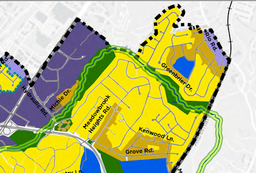
One of the places in the new Future Land Use Map where this comes into play is the conversion of around three dozen parcels in the city’s Greenbrier neighborhood from low-density residential to urban mixed use corridor, something that’s intended to encourage higher-intensity mixed use development.
Some of these properties are the only ones in the city that front Rio Road, where 35,000 vehicles pass a day according to 2021 estimates from VDOT. In all, that stretch is about 0.15 miles long.
Other properties with this designation are along Tarleton Drive, where other lots are among several dozen more that have been converted to medium-intensity residential. All of these properties are currently single-family.
The Zoning Diagnostic + Approach report released last summer envisions buildings up to five stories for some areas with this designation, though this is a rare example of land going from the lowest density allowed to one of the highest.
Some had suggested more density in this area during the Comprehensive Plan rewrite back in 2013, because of the existence of businesses directly across the street in Albemarle County in what’s known as Gasoline Alley. The Places 29 Master Plan adopted in 2011 describes the county properties as being a future “neighborhood service center.” Other county properties to the northwest are “neighborhood residential density.”
The city retained the lower density 10 years ago, but went much bigger in the new plan.
“One of the important concepts of the Comprehensive Plan is to promote walkability and the opportunity for the incremental growth of new commercial spaces,” says James Freas, the city’s director of Neighborhood Development Services. “To that end, the plan sought to identify locations where the land use map could show potential new commercial spaces that would be in a close/walkable proximity to existing neighborhoods with good overall transportation access.”
Someone walking from the intersection of Rio Road and Greenbrier Drive would have a half-mile journey to the Center at Belvedere. CATEC is a third of a mile away. Transit currently runs along the roadway. Albemarle County is likely to receive funding for improvements at Belvedere and Rio roads.
According to Freas, how development in this location actually occurs will depend on how the city’s new zoning code works. That process is underway now with the release of more detailed information happening later this month.
“As we work on the zoning ordinance to implement this plan, one of our objectives is a set of rules that help to manage the interface between neighborhoods and new mixed use and commercial use,” Freas says.
Only a few homes in the section up-zoned for urban mixed use have sold since the new plan was adopted in late 2021. All of those sales have been to couples or individuals, and not to private companies. None of the homes are currently on the market.
Other areas of the city designated as urban mixed use corridor include East High Street, West Main Street, Jefferson Park Avenue, Ivy Road, Preston Avenue, and Fontaine Avenue Extended.