Local filmmakers Paul Wagner and Ellen Casey Wagner’s The Tunnel details the history of the newly reopened Blue Ridge Tunnel, located near Rockfish Gap.
submitted photo
By Lisa Provence
Nothing happens quickly with the Claudius Crozet Blue Ridge Tunnel. Not its mid-19th-century eight-year construction, nor Nelson County’s nearly 20-year effort to reopen it, nor the documentary recently released by local filmmakers Paul Wagner and Ellen Casey Wagner.
“I thought it would only be a few years, weaving the reopening and the history of the tunnel,” says Academy Award-winner Paul Wagner, who directed The Tunnel. “I had no idea it was going to take almost nine years.”
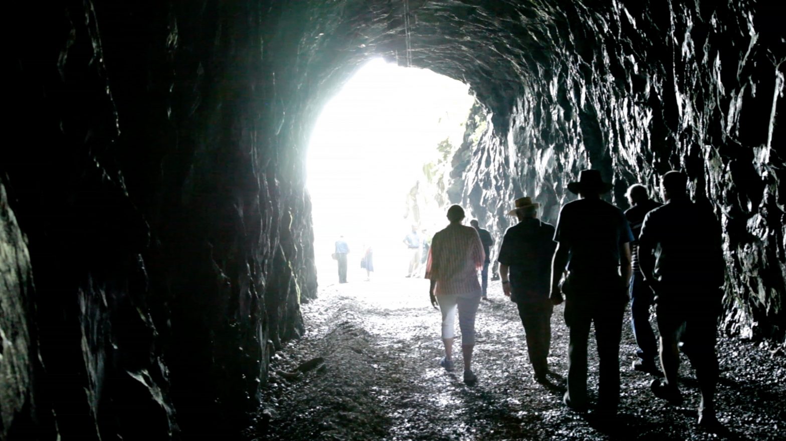
When it opened in 1858, the hand-dug Blue Ridge Tunnel was the longest tunnel in North America. About 800 Irish immigrants used star drills and black powder in those pre-dynamite days to carve through Rockfish Gap’s granite, dangerous work that, along with cholera, killed dozens and maimed many more.
The idea of intercutting the two stories—the difficult construction of the tunnel and the nearly two-decade effort to reopen it—appealed to Wagner, who describes the film as “the creation and re-creation of the Blue Ridge Tunnel.”
Says Wagner, “We’ve made a lot of historical films, and often there are not visual materials to tell those stories. It was nice in this case to have a present-day story that was directly related to the historical story, that gave a story thread in the present that reverberated against the historical story line.”
The film focuses on the Irish laborers who fled the famine in Ireland to find work and who were considered more expendable than enslaved workers. This isn’t the Wagners first Irish-centric film. Out of Ireland traced eight workers in the United States, one of whom worked on the railroad.
The Irish in America “have been an interest of ours,” says Wagner, and The Tunnel, which became available on YouTube on St. Patrick’s Day, uses students from the Blue Ridge Irish Music School to help tell the story with music and dancing—and a haunting violin solo.
The Tunnel also tells the story of the enslaved workers and the institution of slavery “in such a powerful way,” says Wagner.
Engineer Claudius Crozet, who was hired to construct a 17-mile railroad from Mechum’s River in Albemarle to Waynesboro, wrote to his board to explain having to pay $2,400 compensation for the deaths of two Black workers. The enslaved laborers contracted out to Crozet could not be used for the black powder blasting, not out of concern for the men but because of their value as property.
“It was an insight on the thinking of the institution of slavery and how it worked,” says Wagner.
Filming provided some challenges. The eastern portal had waist-high water. “We’re vaguely outdoorsy, but I do not have hip boots in my closet,” says Wagner. “I’d wade into water up to the waist in the dark holding a camera.”
Despite that discomfort, Wagner says it was not an arduous shoot. “One of the joys was that you could just walk in there and turn your camera on and end up with these beautiful images,” he says. “Between the light and the dark, the water, the brick walls, the stone, and especially the lighting as you walk in and out of the tunnel. The lighting effects are so beautiful without even trying.”
During the 1950s, a 12-foot-thick bulkhead was built in the tunnel for propane storage, and blocked passage through until restoration work began in 2018. Wagner describes the magic of seeing the light at the other end of the tunnel after it was blasted out.
“I had been in there many times and never seen light,” he says. He compares the experience to December 29, 1856, when workers broke through the rock. A newspaper clipping said, “Light now shines through the Blue Ridge.”
“This is what it was like,” says Wagner. “I had a little emotional reaction.”
The image of a tunnel is symbolic in itself and often mentioned in near-death experiences, he says. “There’s something powerful, almost spiritual about the tunnel.”
Along with the history, it’s also a great local story, one that ties into the rails-to-trails movement, tourism, and recreation, and intersects with the Appalachian Trail and the Route 76 bike trail, says Wagner. “Go with your kids, ride your bike, but there is a real dark and tragic side of the story that’s worth remembering.”
The film was a labor of love for the Wagners. “We didn’t raise a lot of money to do it,” he says. “We did it as a side project over the years,” ultimately getting some funding from the Claudius Crozet Blue Ridge Tunnel Foundation, the Virginia Tourism Corporation, and Virginia Humanities.
“We want as many people as possible to see it,” he says. Historical preservation isn’t just about places like Monticello or Montpelier, adds Wagner. “This is about historic preservation, too. It’s the common people. It’s landscapes—natural and manmade—that are also valid to think about as historic sites.”
Since the Blue Ridge Tunnel opened in November, 35,000 people have gone through it, according to former Nelson County supervisor Allen Hale.
“I think the film really captured the spirit of the project and paid tribute to the people who built it,” says Hale. “It was a lost treasure. The film does a wonderful job of re-claiming this lost treasure.”
In Virginia's 5th Congressional District, Dr. Cameron Webb fell to Bob Good in a highly contested race. PC: Eze Amos
President-elect Joe Biden swept to an easy victory in Virginia last week, carrying the state with 53.9 percent of the vote to Donald Trump’s 44.2 percent, according to data from the Virginia Department of Elections.
In the 5th Congressional District, Democrats weren’t so successful. Dr. Cameron Webb, UVA’s Director of Health Policy and Equity, fell to Bob Good, a Liberty University athletics administrator and Campbell County Supervisor. Observers around the country noted that Webb ran a sharp campaign while Good fumbled through multiple comical scandals, including a committing a potential campaign finance violation by auctioning off an AR-15 rifle at a rally. Heading into election night, FiveThirtyEight called the district a tossup.
Ultimately, however, Good earned 210,986 votes (52.4 percent) to Webb’s 190,313 (47.3 percent).
The huge, largely rural 5th District has voted for a Republican by a comfortable margin ever since it was drawn into its current form in the last round of redistricting. Four different Republican candidates have run in the 5th since 2012, carrying between 52.4 and 60.9 percent of the vote each time.
The map above shows the margin of victory for Cameron Webb and Bob Good in each of the 5th District’s localities.
Though Webb lost to Good by 5.1 percent, there’s evidence to suggest Webb’s campaign did swing some voters into his camp. Webb outperformed Biden, earning around 7,000 more votes than the president-elect in the 5th District.
Still, that wasn’t enough to overcome the challenges presented by the gerrymandered district.
Two years ago, Democrat Leslie Cockburn lost to Republican Denver Riggleman by 6.6 percent in the 5th. In 2020, Webb managed to flip two of the district’s 23 localities, turning Nelson County and Fluvanna County from one-point losses into one-point wins. Webb also expanded on Cockburn’s 2018 performance in Albemarle, the district’s largest locality, winning 68.2 percent of the vote, compared to Cockburn’s 64.6.
Overall, Webb improved on Cockburn’s 2018 vote share in 15 of 23 localities—but he didn’t improve by more than 3.6 percent in a single locality, and he lost ground in some places.
Webb wasn’t able to make serious inroads into the district’s most populous red localities. In Pittsylvania and Fauquier counties, the district’s two largest localities outside of Charlottesville-Albemarle, Webb won 32.2 percent and 42.1 percent of the vote, respectively. For comparison, in 2018 Cockburn won 30.8 percent in Pittsylvania and 42.4 percent in Fauquier.
“It has truly been an honor to run to represent this district in Congress,” Webb wrote in a statement conceding the race on Tuesday. “This campaign has been a battle of ideas about how to best serve the people of our district and I cannot give enough thanks to everyone who made it possible.”
“Tonight is a victory for the conservative values that founded and sustain this nation, for biblical principles, the sanctity of life, religious liberty, free market capitalism and the importance of faith and family,” Good wrote after his victory.
Democrat Mark Warner also ran ahead of Biden, winning re-election to the U.S. Senate with 55.9 percent of the vote. Two Virginia Dems who flipped red seats in 2018 hung on to their districts this time around. In the 2nd, Elaine Luria beat Republican Scott Taylor for the second time in two years, widening her margin of victory to 5.4 percent, and in the 7th, Abigail Spanberger beat Delegate Nick Freitas by about 8,000 votes.
Virginia Republicans have now lost four straight presidential elections, four straight senate races, and two straight governor’s races. (Not that we’re counting.) Last time Republicans won statewide office was in 2009, when Bob McDonnell was elected governor, and he wound up being charged with a felony and narrowly avoiding prison. This year, the party ran Freitas—last spotted losing to far-right Confederate enthusiast Corey Stewart in the 2018 senate primary—in a winnable congressional race. Republicans don’t have much time on their hands if they want to right the ship before the next governor’s race next November.
Further down the ballot, Virginians overwhelmingly voted to pass an amendment to the Virginia constitution that will reform the way the state draws U.S. congressional and state legislative districts. The amendment places the responsibility for drawing district lines with a bipartisan commission comprised of citizens and legislators of both parties, rather than allowing the majority party to draw lines however they prefer. Some House of Delegates Democrats opposed the measure, claiming that it wasn’t a strong enough reform, but the proposal passed with the support of 65.8 percent of voters.
In a perfect world, new lines will be drawn in time for the 2021 House of Delegates elections. It’s possible, though, that a census delayed by coronavirus could mean new data isn’t available until the 2022 congressional races.
Sunlight slants through the chestnut grove a dust-stirring harvest at the Virginia Chestnuts Bryant Farm and Nursery in Shipman, Virginia. Photo: Zack Wajsgras
Bryant Farms and Nursery in Shipman doesn’t look that remarkable from the road: just acres of hillsides planted with young trees, their straight slender trunks forming a grid pattern. It’s not obvious, from a distance, what species is growing here. But following the gravel drive through the orchard, down into a ravine and up again, one begins to notice the odd-looking green balls hanging from the branches. Fiercely spiky, lime-colored, a little bigger than chicken eggs, these could only be the fruit of the legendary chestnut tree.
Dave Bryant, who with his wife Kim owns these 46 acres, walks up to one of his 1,600 trees and steps on a fallen fruit laying in the shade beneath it. Its husk, which would poke holes in your skin as surely as any defensive desert cactus, gives way under his boot and splits neatly into four petal-like quadrants. Inside is a trio of dark nuts, as smooth and inviting to the touch as their husk is forbidding.
This is early October, and as Bryant explains, the trees have been dropping nuts for about three weeks, with perhaps a week to go. “They’re 10 years old, and they’re just coming into peak production,” he says. The farm illustrates the mid-harvest moment, with pieces of dry brown husk on the ground, other fruit still waiting green in the trees, and processing equipment at the ready in the barn.
Kim and David Bryant grow, process and distribute chestnuts from their farm in Shipman, Virginia. The 2019 harvest provided a bounty of 15,000 pounds of nuts. Photo: Zack Wajsgras
It’s curious how unfamiliar the trees are—their leaves and fruit seeming slightly alien—considering that the American chestnut was once a key native species throughout Appalachia. Richard Powers’ tree-obsessed novel The Overstory captures their beauty and importance:
“The chestnuts up North were majestic. But the southern trees are gods. They form near-pure stands for miles on end. In the Carolinas, boles older than America grow ten feet wide and a hundred and twenty feet tall. Whole forests of them flower in rolling clouds of white. Scores of mountain communities are built from the beautiful, straight-grained wood. A single tree might yield as many as fourteen thousand planks. The stocks of food that fall shin-deep feed entire counties, every year a mast year.”
Powers goes on to describe the tragic, mind- boggling epidemic that saw America’s four billion chestnut trees fall prey to blight in the early decades of the 20th century. Accidentally introduced from Asia, the fungus spread rapidly from its entry point in New York City and within 40 years had wiped out nearly every chestnut in the country. Though chestnuts lived on in cultural memory, they left a glaring absence in the actual forests.
Comeback crop
Dave Bryant says he wasn’t really pondering this history when he decided to plant a chestnut orchard. He and Kim just wanted to find a profitable crop to raise in their retirement, something they could physically handle as they grew older (as opposed to, he says, green beans that must be picked while bending over).
Wry and gregarious, with a neat white goatee, Bryant grew up in Nelson County and worked as a software developer before buying this property in 2002. The couple stumbled on the notion of chestnut farming as they researched many potential crops. Luckily for them, and for everyone who enjoys eating chestnuts, there are now hybrid varieties available that are bred to resist blight. The Bryants chose the variety Dunstan: 95 percent American chestnut, with 5 percent Chinese chestnut genes offering protection from disease.
“Its husk, which would poke holes in your skin as surely as any defensive desert cactus, gives way under his boot and splits neatly into four petal-like quadrants. Inside is a trio of dark nuts, as smooth and inviting to the touch as their outer shell is forbidding.” Photo: Zack Wajsgras
“Later, we said, ‘This is romantic,’” Bryant says—referring to the act of replanting 23 acres in Appalachia with a species that once held such significance here. But it’s harvest time, and practical matters come first.
For example, the Bryants and their helpers know that any nuts left lying on the ground overnight are likely to end up feeding deer—so they make a point of harvesting in the last hours before dark. “They fall to the ground naturally,” says Bryant. “We pick them up by hand, or I have a harvester I pull behind the tractor.” The machine’s rubber fingers flick the nuts onto a mesh conveyor belt that delivers them into plastic totes.
Lots of husks, sticks, and rocks end up in those totes too, which is where the pre-cleaner machine (nickname: Ethel) comes in. Sorting materials by weight and size, Ethel separates the “trash” from the nuts—“a lifesaver for us,” Bryant says. “We did it manually for the first couple of years.”
Ethel is officially designed to clean pecans, which speaks to the fact that chestnuts are a specialty crop, not as tightly woven into our culinary culture as other nuts. Having joined with four other growers in central Virginia to form the cooperative company Virginia Chestnuts, Bryant sells much of his product in cute two-pound burlap sacks at holiday markets and roadside stops. (A two-pound sack on virginiachestnuts.com costs $17.) They may not be a staple like walnuts or almonds, but they do enjoy a close association in American tradition with Thanksgiving and Christmas, which certainly helps move product. November, says Bryant, is the most important sales month on the chestnut grower’s calendar.
He’s pleased with this year’s crop, which he expects to weigh in at around 15,000 pounds. “It’s been so dry,” he says, “but the chestnuts are a nice size. You want them to have that red mahogany color”—and to feel very firm when squeezed.
As an entity, Virginia Chestnuts lives on the Bryant farm and is mostly run by Dave and Kim, but it’s meant to make life easier for all five of its member growers. A decade ago when they were just starting to plant their orchards, Bryant says, “We decided, ‘Let’s not all buy [our own] equipment and do processing.’” Apple growers had formed similar co-ops in the past, pooling resources to make washing, packing and marketing more efficient.
The group sells mainly fresh chestnuts, but Bryant says there’s a limit to that market, and as the growers’ crops continue to burgeon, they’ll begin to supply other products: dehydrated and frozen chestnuts, plus chestnut flour. Bryant expects future yields to reach 50,000 pounds per year.
After getting washed in a tank fitted out with bristly rollers, the chestnuts go inside to a sanitary processing room, where they get pasteurized, dipped in food-grade hydrogen peroxide, dried on racks, and chilled in walk-in coolers. As for the trees outside, they’re starting to close the gaps between their crowns, so they’ll soon be thinned to leave more space for each one to grow. Their mature height will be around 40 feet.
It’s different than the old-time stories of families wandering the mountains, shaded by chestnut trees 10 stories tall, and filling baskets with the natural abundance of the forest—a food given freely by the Appalachian environment and the giant trees it nurtured. But this orchard is a link to that time, experienced with all the senses: the sharpness of the husk, and its inner lining as velvety as a rabbit’s ear; the weight of the shiny dark nut in your hand; the moist yellow meat inside the skin that smells faintly of grass and cracks audibly when you bite into it. Mild, sweet, and satisfying, the flavor of a fresh raw chestnut is a true local delicacy (to say nothing of the sublime things that happen when you roast it—in your oven or, as the song has it, on an open fire).
Says Bryant, “You can’t hardly beat that as a snack.”
Whole families and homes were swept away in Davis Creek, the hardest hit community in Nelson County.
Nelson County Historical Society
Fifty years ago, man first walked on the moon and a music festival in Woodstock, New York, signaled a generational shift. As iconic as those events are, that’s not what Nelson County remembers about 1969, when the remnants of Hurricane Camille latched onto the mountains the evening of August 19 and dumped around three feet of rain. By morning, 124 people were dead, some of whom were never found.
Warren Raines was 14 years old when the water from the Tye River started rising and seeping into his house in Massies Mill.
His most vivid memory of Camille 50 years later? The funeral of his family about a week after the storm. “I’d never seen anything like it. To have four caskets lined up there. My little sister hadn’t been found then or it would have been five.”
That night, Raines “became an orphan and lost my childhood,” he says. He doesn’t enjoy talking about it—“I get more emotional than before.” But he does talk about it, which some people still can’t do even now. “If you don’t tell people what happened, they don’t know,” he says. “They don’t know about the rainfall.”
Raines compares Camille to July’s Hurricane Barry, which dropped 20 inches of rain in Louisiana over three days. “We got as many as 32 inches in eight hours,” he says. Many have described Camille’s precipitation as raining so hard that you had to cup your hand over your nose to be able to breathe.
Nelson County is remembering Hurricane Camille as the anniversary of “the 19th,” as it’s called there, approaches. The Nelson County Historical Society has offered programs that look at the local response to the flood, meteorological factors, and the pilots who flew in to find those swept away, as well as a concert headlined by former Statler Brother Jimmy Fortune with Bennie Dodd and Joey Davis, all Camille survivors.
Woody Greenberg, who’s on the historical society board, assesses the impact of Hurricane Camille on Nelson 50 years later: “Definitely it’s a psychological scar that’s not going away for the people who lived through it,” he says. “Some people will talk about it who wouldn’t before, and we’re trying to preserve their stories.”
This small rural county of around 11,000 people lost 1 percent of its population, and survivors say most knew at least one person who died—in some cases, many more.
Even to those who were there, the scope of the devastation wasn’t immediately apparent. The four-lane U.S. 29 bypass had just opened, but debris at Woods Mill made the highway impassable to the north. Flooded waterways in the south end of the county also impeded travel. With telephone lines downed, it took the outside world several days to learn that an unprecedented disaster had taken place in Nelson.
“More water than I’d ever seen”
Bar Delk was 22 years old, a VMI grad who was headed to Fort Benning in January and then to Vietnam. He’d been in Charlottesville the evening of August 19 and was driving home. “The farther we came, the harder it was raining,” he says. “When I got to Woods Mill, there was water coming across the road. Five tractor trailers were parked there and weren’t crossing.”
Those five tractor trailers washed away, he adds. “We found two of them. Three tractor trailers were never found.”
A river runs through it: U.S. 29 bypass at Woods Mill. Nelson County Historical Society
A few years earlier, Delk had a summer job working on the highway, and with a local’s confidence, felt he could get across. He concedes, “That was more water than I’d ever seen.”
He made it to Lovingston, where water was pushing into the IGA. “We cleaned it up a couple of times before the wall caved in,” he says. A trailer was on fire, but no one could get out of town because the entrances were blocked, he says. “We realized something was going on.”
In the western part of the county, by 2am, the Raines family decided to relocate to higher ground. Their neighbors, the Woods, sent their four children—Donna Fay, Gary, Teresa, and Mike—to pile into the Raines’ car, where Warren had gathered with his parents and siblings: Johanna, 18, Carl, 16, Sandy, 9, and Ginger, 7.
Rising water killed the engine and the refugees took to Route 56. No one realized how rapidly the water was rising. “In less than two minutes, it went from knee deep to four or five feet deep,” says Raines. “The water was so swift you couldn’t stand against it.”
Warren and his brother Carl clung to trees and were the only ones in his family who survived the rising water. Two of the Wood children—Donna Fay and Gary—were among the 33 people whose bodies were never recovered.
For the next couple of years, Raines lived with another family. In his senior year of high school he went back to the homeplace, where the first floor had flooded during the storm. “The upstairs was untouched,” he says. “That was sad. If we’d stayed…”
Warren Raines still lives in Nelson County, and remembers his childhood home in Massies Mill as a happy place. He became an orphan August 19, 1969, when he lost five family members. Sanjay Suchak
He’s philosophical about what might have happened. “If we’d stayed, it would have been a frightening night. The lightning was like day. We would have seen the water rushing by with homes, automobiles. We would have been waiting for the house to break up.”
He pauses. “If is such a big word.” He’s aware that others who remained in their homes were swept away that night. “If we’d done that. If we’d not done that.” It was impossible to know.
Declaring a disaster
Jane Raup was 14, living in Wingina in the southeast part of Nelson County on the James River, and she awoke to see flooding in the fields around her home. “We had no idea what was happening at this end of the county,” she says.
Her father, Cliff Wood, was on the board of supervisors. He and two cousins put a jon boat on a truck and made it as far as Howardsville, where they rescued two people on a roof, she says.
“All this water on the Rockfish River—he realized something was going on,” she says. He took back roads to Lovingston to check on her grandmother, who told him, “I hear it’s bad at Davis Creek,” Raup remembers.
It was, in fact, really bad at Davis Creek, in the northern part of the county, where 52 people died. In the Huffman family alone, 18 perished. Aerial photos show Davis Creek turned into a river of rock going down the mountainside. The bodies of 20 people who died were never found.
In Lovingston that day, Wood ran into Bob Goad, the commonwealth’s attorney. They drove up U.S. 29 to Muddy Creek, which had flooded, and a house was in the middle of the median.
“Someone asked if it was a disaster,” says Raup. The county’s civil defense team had been preparing for a nuclear disaster, not a natural disaster. But as the only supervisor who could make it to the county seat, Wood declared a disaster, his daughter recounts, and took charge of the recovery and relief effort.
“Local governments have a responsibility in those situations,” Wood said in 2009. “That’s how I got involved.”
Wood set up the command center on the new bypass. “He said, this is the perfect place. It’s flat,” says Raup.
When Wood made it home that night, he told his family, “You wouldn’t believe it.” Says Raup, “He was in shock. I think everyone was in shock.”
The U.S. 29 bypass around Lovingston had just opened. It became the command center and landing strip for the search and relief effort. Brower York Jr./Nelson County Historical Society
Nelson Sheriff Bill Whitehead lived in the western district of the county, near Massies Mill and Tyro, and he couldn’t get to Lovingston, says his son, Dick Whitehead, who was almost 18 when the hurricane struck.
Like others, he was trapped by washed out bridges. But he was able to make a radio distress call that was heard by the sheriff’s department in Augusta County, which alerted the civil defense office in Richmond. John Kent, the Augusta sheriff, sent a helicopter to Nelson.
“The first day, you’re hoping to find survivors,” says Dick Whitehead. “It was still a rescue. By the first night, it was obvious it was not a rescue. It was a body recovery.”
Yet that first day, it was still hard to fathom how bad it was. “You don’t realize how many houses had washed away,” he says. Nor did he immediately understand how many people he knew who had died.
Thirty in the Nelson County school system died, he says, and estimates he probably knew 15 of them. Three were in his class, including Warren Raines’ sister, Johanna. But on August 20, he had no idea what to expect. “You can’t prepare yourself for that when you look out the window on the first day.”
The image of the overturned Bland Harvey house in Roseland has been published more than any other Camille photo. Brower York Jr./Nelson County Historical Society
Fifteen-year-old Phil Payne wasn’t aware anything was amiss when he awoke the morning after the storm in parents’ house, a mile south of Lovingston. “That’s what makes this storm unique,” he says. “We didn’t know. It’s mind boggling. The communications did not exist.”
His father, who owned the Chevrolet dealership, got a call from his bookkeeper, who said she couldn’t get to work because a house was in the middle of the road. “He didn’t really believe her,” says Payne.
After breakfast, he went with his father to Lovingston and saw mud in front of the IGA. They drove—or got rides when the road was blocked—up U.S. 29. “It was a matter of just yards,” says Payne, determining whether residents lived or died.
It wasn’t until midday that the rescue process began. “I don’t think anyone could grasp the scope of the disaster,” Payne says. “You have a flood in the mountains. How did that happen?”
His father coordinated search and rescue—although “by then there was no rescue,” says Payne.He went up in helicopters multiple times.
Because other volunteers hadn’t arrived, he and his friends searched. They found three bodies the first day. After a few days, his father decided maybe that wasn’t the best job for teenage boys. “Dad pulled some of the young guys out of it, including me,” recalls Payne. “That didn’t last long.”
Some of the older men had to go back to work and Payne continued to search during a period of time that all ran together. Later, he tried to label some photos he’d taken. “I was off by one week on every one,” he says.
The force of Camille
In the Nelson County Historical Society archives, there’s this entry: “The height of the storm—midnight to 3am; Most victims were nude when found.”
The force of the water stripped off clothes and even wedding rings, and people either escaped injury entirely, “or they died,” said Dr. Robert Raynor in 2009. He assisted chief medical examiner Dr. James Gamble, and said the dead either drowned or suffered blunt force trauma from the tons of debris surging through the water.
A home on the Rockfish River after Hurricane Camille. Nelson County Historical Society
And it was the water that caused mountains to melt. “It was one of the most catastrophic, historic floods to hit the U.S.,” says Jeffrey Halverson, a geography and environmental sciences professor and severe storm expert for the Washington Post.
Hurricane Camille reached the Gulf Coast as a Category 5 storm—“one of only three to hit the United States in the 20th century,” says Halverson. But after killing 174 people there, it was losing steam as it headed north and had transformed to a depression, he says.
The local forecast called for a chance of showers, clearing in the morning. “The fact it roared back to life in Virginia was a tremendous surprise to everyone,” says Halverson.
He lists five pieces in a “conspiracy of circumstances” that turned Camille into a killer again. It contained remnants of low pressure that were pulling moisture into the air. The mountains helped accelerate that. In addition, a cold front moved into central Virginia from the north and parked. A disturbance in the jet stream over central Virginia also caused moist air to rise. And to top it off, the ground was “very, very wet,” says Halverson. Evaporation from the saturated ground enriched the air with higher levels of moisture, causing extremely high humidity.
Any one of those factors independently can cause moist air to rise, says Halverson. All together, “they conspired to produce one of the most intense rainstorms ever documented in the United States.”
For eight hours, at least 30 inches of rain fell over Nelson County, although that’s believed to be a minimum as most rain gauges washed away—and they don’t measure 30 inches anyway. “That’s almost three feet of water,” he says. “This system kept generating itself over eight hours.”
Here’s what happens when 30 inches of rain falls in a short period: “The land surface cannot accommodate that volume of water,” says Halverson. Add to that the steepness of the mountains and the denseness of the soil on top of bedrock. “It was like a sponge. This huge, tremendous weight gave way. Whole sides of mountains came down…mud, vegetation, rock, and even habitation.”
Mudflows from hundreds of locations where the slopes gave way coalesced and merged, burying rock and anything else in its path many feet deep, says Halverson. “It literally tore apart the land.”
You can still see those bare spots on the mountains around Nelson today. When helicopter pilot Douglas Neims flew into Nelson in 1969, he saw what looked “kind of like ski area tracks going through the trees, but it was mud and landslides.”
Neims, who had returned from Vietnam in 1968, was one of many vets who used their piloting skills in getting in and out of difficult spots to help with the rescue effort. He remembers flying south to Lovingston from Fort Belvoir over a lush, green Virginia in August—”until you fly over a hill and you’re looking at total devastation. You could see houses and cars buried. It hit you that this was devastation.”
Many Nelson residents oppose the Atlantic Coast Pipeline, and some point to Camille and its thousands of landslides as an example of why the pipeline is a bad idea.
Anne Witt, a geohazards specialist with Virginia Department of Mines, Minerals and Energy, which has mapped over 5,000 landslides from Hurricane Camille, says, “Any large construction project that includes large excavations in soil and rock should take geological hazards (including landslides) into consideration during the building process.”
Geologists at the department are using a laser system to develop landslide susceptibility maps for the area, but Witt says the project is still in progress, and hasn’t reached any conclusions yet. It’s expected completion date is 2021.
50 years later
Over the course of half a century, any locality will change. In 1969, Nelson County was a farming community with two major employers—American Cyanamid, which extracted titanium dioxide and created a superfund site on the Piney River, and Alberene Soapstone in Schuyler.
Both are now closed. There’s still some farming, but “the small orchards did not recover,” says Woody Greenberg. “Years ago, every farm had an orchard.”
That includes Clyde Harvey’s family farm, at the top of Davis Creek. And although his orchards were damaged, in trying to salvage trees he discovered the Ginger Gold apple, which he patented. Says his daughter Debbie Harvey, “Ginger Gold came from Davis Creek.”
Since Camille, Wintergreen has been built, along with microbreweries and wineries. “Now the tourism industry is thriving,” says Greenberg.
Bar Delk still finds it odd that the county would go from making illegal moonshine and peach brandy to legal alcohol. “Who would have thunk it?” he asks.
For Warren Raines, the sound of a helicopter brings back memories of Camille. “So many helicopters,” he says. He recalls a strange smell to the mud that he’s only smelled one other time, possibly from stagnant mud at a construction site.
Helicopters also trigger memories of Camille for Jane Raup, and she remembers an aroma that was “part decay, part green wood.”
In 1969, school was delayed a month. “I remember seeing Warren’s brother standing in the door to the cafeteria, wondering what to say to him,” she says. “There was no counseling. We didn’t know about PTSD.”
Unlike Warren Raines, who says he never wanted to leave Nelson County, Carl Raines left and never came back.
The home of Nina Fitzgerald ended up in the median strip of U.S. Route 29 north of Lovingston, courtesy of Hurricane Camille damage. Blair Clarke Camille Photo Collection/Nelson County Historical Society
Of the many heroes from Camille, one group stands out. “Nelson County really loves the Mennonites,” who showed up to recover bodies, shovel mud, and help rebuild homes, says Raup.
The hurricane “made us aware we needed a 911 emergency system,” she says, and bridges and roads were improved when they were rebuilt.
“I do believe those of us growing up then are closer,” says Raup. “There’s a bond there.”
For Dick Whitehead, the big difference between the 50th anniversary and the 40th is “fewer and fewer people who have first-hand knowledge” are still around. So many of the people “who got us through this,” like his own father, are gone.
There’s more awareness now of floodplains, and very few homes were rebuilt in those areas, he says. “That’s a positive.”
The news isn’t so positive in areas where there were rockslides and people have built. “Maybe they didn’t do the research,” he says, “but some are building in vulnerable areas.”
Houses collided in Massies Mill, where the Tye River flowed down Route 56. Nelson County Historical Society
The big question: Can the devastating effects of Camille happen again?
“Absolutely,” says Halverson—and you don’t even need a hurricane.
He points to Madison County in 1995. A summer system of thunderstorms dropped more than 20 to 25 inches of rain in 12 hours, he says. Three people died, and there were “terrific flash flooding and debris flows.”
Says Halverson, “We see in less than 30 years two extreme rain events along the Blue Ridge Mountains due to these torrential cloudbursts.” He sees no reason to think this didn’t happen in the past before people were around to measure it, given the area’s steep mountains and “unlimited supply of moisture.”
He says, “You’re experiencing thousands of years of erosion in the space of a few hours.”
And with a changing climate and rainstorms becoming more intense, combined with the “proclivity of more people moving into harm’s way in these locations,” he says it could happen again, maybe not in the same location, but anywhere up and down the Blue Ridge Mountains.
Halverson offers this advice: Don’t forget about a hurricane once it makes landfall because it can spring back to life. Hurricane Agnes started in Florida in 1972, and created Pennsylvania’s worst flooding ever, he says. In 2004, Hurricane Ivan hit Florida and continued on to drop 50 to 60 tornadoes over Washington, DC.
“Over and over, we see these remnants gaining strength,” he says.
There are some tremendous lessons to be learned here,” observes Halverson. “It’s a dramatic story.”
Remembering Camille
A memorial for the victims, with music and photos, will take place Sunday, August 18, at 2pm at Nelson County High School.
And a forthcoming book, Commemorating Camille: Never Forget, edited by Doris Delk, Bar Delk, Dick Whitehead, and Woody Greenberg, tells the stories of the 18 communities affected by the hurricane. It will be available at Oakland Museum the third week in August.
Along with the Civil War, Hurricane Camille was one of the deadliest events to hit Nelson County. Sanjay Suchak
Death toll: 124
Fatalities in Nelson weren’t limited to one part of the county.
By the time the rain stopped on August 20, 1969, Hurricane Camille had killed 124 people in Nelson County. This map indicates where they perished—some of the bodies were never found.
The rocket's red glare, the comfy lawn chair—you get the picture. Happy 4th of July! Photo: Jack Looney
From the mountains of Wintergreen to the valley where Scottsville sits, the Charlottesville area is exploding with Independence Day celebrations. Bonus: Since July 4 falls on a Thursday this year, party time stretches out over a long weekend. What this means is that, in addition to barbecuing in your local park or backyard, you can also partake in one (or more) of the many patriotic offerings by local municipalities and businesses. Boom! Just like that.
June 29
Crozet Independence Day Parade and Celebration
The parade, led by the volunteer fire department, starts at Crozet Elementary School and snakes along Crozet Avenue through downtown to Claudius Crozet Park, where all sorts of fun will ensue. Roots rock band Jacabone takes the stage, and kids’ games and rides (including bounce houses and laser tag) will be available, along with plenty of food. Adults can enjoy local refreshments by Bold Rock Cidery, and Starr Hill and Pro Re Nata breweries. 5pm parade and party, 9:30pm fireworks, suggested donation $4 per adult and $2 per child 12 or younger, crozetcommunity.org.
June 30
Free Union Independence Day Parade
Decorate a wagon, bicycle, scooter, dog, horse, or float and join the parade from the Church of the Brethren to Free Union Baptist Church. 4pm, free, Millington Road, Free Union 973-7361.
Charlottesville’s Khizr Khan, whose speech at the 2016 Democratic National Convention made him a prominent advocate for religious tolerance, will deliver the keynote address at Monticello’s July 4 naturalization ceremony. Photo: Eze Amos
July 4
4th of July in Scottsville
The little town on the James River’s annual Independence Day features a morning parade led by the Scottsville Volunteer Fire Department, complete with floats and musical performances. The party continues all day long and into the night at Dorrier Park, with more music, food, and fireworks. This is a biggie—estimated attendance is 7,000! 9am-10pm, free, James River Road, Scottsville. 531-6030, scottsville.org/events.
Independence Day Concert and Celebration
Celebrate at the home of President James Monroe, a Revolutionary War veteran who died July 4, 1831. Enjoy a live performance by musicians from the Heifetz International Music Institute, as well as children’s crafts and historic games. 2pm, free, 2050 James Monroe Pkwy. 293-8000, highland.org.
Independence Day Celebration at the Frontier Culture Museum
This annual event includes a reading of the Declaration of Independence, games, a pie eating contest, crafts, and historical re-enactments. 9am, free, 1290 Richmond Rd., Staunton. (540)332-7850, frontiermuseum.org.
July 4th at Monticello
Monticello hosts its 57th annual Independence Day celebration with a not-to-be-missed naturalization ceremony; this year, more than 70 people will take the oath to become U.S. citizens. (The scheduled tour of Thomas Jefferson’s residence is sold out.) The keynote speaker is Charlottesville resident and Gold Star parent Khizr Khan, whose son, UVA grad and U.S. Army Captain Humayun Khan, died in 2004 trying to stop a suicide bomber in Iraq, and was awarded a Purple Heart and a Bronze Star. Since Khan’s headline-making speech at the Democratic National Convention in 2016, he has continued to advocate for religious tolerance. 9am, free, 931 Thomas Jefferson Pkwy., 984-9800; attendees are urged to register at monticello.org for free shuttle transportation to the event from Piedmont Virginia Community College (501 College Dr.), monticello.org.
Nelson County Fourth of July Parade
Nelson County kicks off Independence Day with a children’s bicycle parade followed by a bigger one with floats, marching bands, antique cars, and more. 10am, free. Front Street, Lovingston, 906-1200, nelsoncounty-va.gov.
Patriotism in the Park
McIntire Park is the epicenter of Charlottesville’s July 4 celebration, with local bands, food, and family-friendly activities leading up to the annual fireworks display. 5pm, free, shuttle service available from the Albemarle County Office Building and Charlottesville High School, 970-3260.
Red, White, Blue in Greene Independence Day Celebration
Greene County’s celebration begins this year with a parade down Main Street, and the festivities end with a major fireworks display. Live music, food trucks, and many activities for children and adults. 5-10pm, free, Stanardsville, (540)290-8344, rwbng.org.
Happy Birthday America at Carter Mountain Orchard
Hayrides, family-friendly games, live music all day, and a nearly 360-degree view of the area’s fireworks displays. Oh, and adult beverages from the Bold Rock Tap Room and the Prince Michel Wine Shop. Noon-9:30pm, 1435 Carters Mountain Trail, 977-1833, chilesfamilyorchards.com
July 4-7
July 4th Jubilee
Wintergreen Resort’s celebration churns on through the weekend with live music and activities including a bonfire, arts and crafts, stargazing, an outdoor movie, a block party for kids, chairlift rides, games, and axe throwing (yes, you read that correctly). 9am July 4 through 8pm July 7, activity prices and times vary, Route 664, Wintergreen, 325-2200, wintergreenresort.com/July-4th-Jubilee.
Locals call the swath of clear-cutting near Wintergreen the “Tuesday Chainsaw Massacre.”
Photo Ben Cunningham
A “jumbled mess” of hundreds of clear-cut trees still lie at the entrance to Wintergreen, across Route 664 and up the side of Piney Mountain.
Dominion Energy started knocking them down to make way for its Atlantic Coast Pipeline in Nelson County on March 6, a day the locals now refer to as the “Tuesday Chainsaw Massacre.”
Because the Federal Energy Regulatory Commission ordered the company to quell its tree felling until the fall to respect the flight patterns of migratory birds and the state’s population of endangered Indiana bats, it’s been awful quiet in Nelson County—but probably not for long.
Wintergreen resident David Schwiesow estimates that the company building the pipeline has only completed 10 percent of its total destruction in his area.
“Dominion will be coming back to continue the rape of Piney Mountain,” he says, estimating that 7,000 trees, plus rhododendrons, mountain laurel and other ground cover will be cut before it’s all said and done. “So the worst is yet to come at Wintergreen.”
When FERC approved construction of the ACP in October and prohibited Dominion from clearing trees from mid-March to September in Virginia, Dominion agreed. But as the time to stop cutting came closer, the company asked for permission to extend its clearing period by two months—a request that FERC denied on March 28.
“We are cautiously optimistic that FERC will stick to this decision,” says Schwiesow. “In the past, FERC has rubber stamped everything Dominion has requested.”
The clear-cutting has devastated those living near it, he says.
“Wintergreen residents are horrified by the destruction, including many who hadn’t really paid attention to the issue,” he continues. “One neighbor of ours on Fortune’s Ridge told us that she pulled off [Route] 664, got out of her car, looked at the destruction and just started to cry.”
The Department of Environmental Equality has cited Dominion for at least 15 clear-cutting violations, and the Wintergreen resident says he and other pipeline opponents are reporting a couple more from the alleged damage done in their neck of the woods. They’ve measured trees cut within 50 feet of a stream across the entrance to the resort, and also within 50 feet of the south fork of the Rockfish River on the other side of Route 664, aka Beech Grove Road.
“Dominion is arrogant and seems to believe that they’re above the law,” says Schwiesow.
Dominion spokesperson Aaron Ruby says his company wasn’t able to clear all the trees they’d hoped to this year, so that work will be pushed into the fall and the beginning of next year.
In the meantime, contractors are clearing and grading at ACP compressor station sites, and after they get a few remaining approvals this spring, they’ll start constructing the pipeline along the 200 miles of the route that have already been cleared from West Virginia, through Virginia and into North Carolina. They’re still on track to wrap up construction by the end of next year, he says.
That doesn’t bode well for the heavy opposition that has amassed since the project was proposed in September 2014.
On St. Patrick’s Day weekend, Schwiesow attended a protest at the resort’s entrance with about 100 other pipeline opponents, including his wife, Nancy, who gave a short speech.
“To some, it feels like the end of the fight,” she said to the crowd. “Dominion has won. But that is wrong.
I am more angry, upset and determined to fight Dominion and its despicable pipeline than I ever have been.”
Hundreds of anti-Atlantic Coast Pipeline activists have emerged to monitor construction on the $6 billion gas fracking project.
A coalition of more than 50 anti-pipeline groups called the Allegheny-Blue Ridge Alliance launched the Pipeline Compliance Surveillance Initiative last week to ensure strict application of environmental laws and regulations for the ACP, which they say will wreak havoc on its 600-mile course from West Virginia, through nearby areas in Virginia like Nelson and Buckingham counties and into North Carolina.
Volunteers with Pipeline CSI will initially focus on monitoring the many mountainous areas of the pipeline route, where they say pipeline construction threatens water quality in the headwaters of major watershed systems.
“We will continue to challenge the government decisions involving the project,” says Rick Webb, an activist who has been instrumental in the fight against the pipeline since the project was announced in September 2014, and who now chairs Pipeline CSI. “But with certain pre-construction activities already underway, citizen oversight is essential given the limited resources of government agencies that are responsible for regulating pipeline construction.”
Dominion Energy and Duke Energy are the major companies backing the ACP. The Federal Energy Regulatory Commission, which gave them approval to start building it in October (subject to other state and federal approvals), also approved limited tree felling along the pipeline’s route on January 19.
Dominion has started knocking down trees in Virginia and West Virginia, according to spokesperson Aaron
Ruby, who says his company only needs a few more approvals before Dominion requests a notice from FERC to proceed with full construction, which he expects to happen by spring.
But not without the watchdogs.
“The need for citizen oversight of pipeline construction has been made clear by observations of recent pipeline projects and ineffective government agency response to repeated violations and water resource harm,” says Webb. “We have no reason to expect more from the agencies during construction of the ACP.”
Skiing, snowboarding, skating or tubing: on your feet or on your rear, straight or in circles,
down the hill or up and over the obstacles—however you like to slide and however you like your winter sports, Wintergreen Resort in Nelson County’s Rockfish Valley has a hill, a park, a rink, and a great white way for it. The four-season resort boasts 130 slide-able acres with 24 ski and snowboard slopes and trails, two terrain parks, the state’s largest tubing park, and a snow park for young kids. If it’s cold, there is joyful motion on Wintergreen’s 11,000 acres, situated on the eastern slopes of the Blue Ridge Mountains.
“The breadth of recreational opportunities at Wintergreen makes it one of the most varied and complete resorts in the country,” says Rod Kessler, the new General Manager of Wintergreen Resort. “The possibilities for what can be done to maximize the guest experience here were too intriguing to pass up.”
Makin’ Snow Wintergreen’s state-of-the-art computerized snow system, dubbed Snowpower, was installed during the winter of 2002 and 2003 and has been upgraded frequently since. The super system uses some 40,000 linear feet of pipeline, more than 400 snow guns, and 45 weather stations.
Capable of converting 8,000 gallons of water per minute into snow, this complex system makes twice as much snow twice as fast as the previous system, giving Wintergreen’s snow sports surfaces a uniform depth and consistency of snow quality from the top of the slopes to the bottom. The system also allows the resort to recover more quickly from rain or unseasonably warm periods, making possible its extended snow sports season. It also makes Wintergreen the East Coast’s only resort with an automated snow making system that covers all its slopes.
As is typical for this part of Virginia, this year’s long term weather forecast calls for a prolonged cold wave beginning right around mid-December. Wintergreen’s snow season begins then and runs through mid-March. But how often can snow fans really expect to find the stuff?
“The science of snowmaking depends on temperature, humidity, wind speed and direction, adiabatic lapse rate, and more,” notes Wintergreen spokesman Mark Fischer. (The adiabatic lapse rate—for those of us who were liberal arts majors—is the rate at which atmospheric temperature decreases with increasing altitude in conditions of thermal equilibrium). “But as a rule of thumb, if it’s 27 degrees Fahrenheit outside, Wintergreen slopes will be white.”
Snow Play Wintergreen hosts about 200,000 total visitors a year, and skiing is by far its most popular winter sport. About 75,000 visitors come to ski. Another 25,000 come to snowboard. Twenty-eight percent of Wintergreen’s snowy terrain is considered suitable for beginners, while 16 percent is more difficult; 44 percent is more challenging yet, and 12 percent is for experts only.Ski slopes include the Cliffhanger, a double-black-diamond expert hill, and Outer Limits, a 2,000-foot single-black-diamond. Eagles Swoop and Tyro are for intermediate skiers. Upper & Lower Dobie are for beginners.
Wintergreen’s Terrain Park is the place to hone freestyle ski skills. It’s progression of more than 40 features is designed to accommodate a variety of skill levels. Frequent changes to the layout of those features keep it challenging even for daredevils. On any given day the park might feature tabletops and fun boxes, spines and hips, straight, rainbow, and s-rails, battleships and down-kinks. A dedicated lift takes users back up the slope fast—but not as fast as they go down!
Virginia’s largest tubing park, the Plunge, is built on a hill longer than three football fields. Tubing fans (ages 6 and up, and at least 42 inches tall) zoom down this “Scream Machine” at speeds up to 30 mph, then take a conveyor lift back up and do it again.Slide, glide and spin fans can enjoy the 45×90 foot Shamokin Ice Rink located in the heart of the mountain village, just off the Blue Ridge Terrace. Refrigerated by a 125-ton chiller, it accommodates up to 60 people at a time.
Fun While Learning Wintergreen Resort offers ski and snowboard instruction for all ages and ability levels based on the American Teaching System. The five-week Mountain Mornings ski program for kids ages 3-6 includes approximately two hours of on-snow time per lesson, a four-hour lift ticket, and rental equipment. Parents are encouraged to ski for free, or relax in the Terrace Café while their kids learn. The Treehouse offers half and full-day programs for kids 4-14, plus childcare for kids 2 and a half to 12. The Childcare + Snowplay for ages 3 and up is a full-day program offering an hour of introductory ski instruction, plus arts, crafts and group games.
Ridgely’s Rippers offers a full-day program for ages 4-12with approximately four hours of ski lesson instruction, lunch, snacks and hot chocolate. The Ridgeley’s half-day program includes approximately two hours and fifteen minutes of instruction and one snack break. Children who are four will take longer breaks throughout the day, so their time on skis may vary depending on participation levels.
Mountain Explorers is for kids ages 7-14, skiing at intermediate level 4 and above. Each participant must be able to ski on their own proficiently and be able to ride Blue Ridge Express and Big Acorn chairlifts without assistance. The full-day program includes approximately four hours of advanced ski lessons, lunch, snacks and hot chocolate. The half-day program includes approximately two hours and fifteen minutes of instruction and one snack break. Children must have completed all levels of Ridgley Rippers, or have one of our instructors evaluate their skiing prior to being enrolled in Mountain Explorers.
Mountain Explorers Pro is a five-day program for intermediate-advanced skiers ages 7-14, which offers the same level of instruction as is found in the Mountain Explorers single-day program. A Mountain Explorers pass may be used on five consecutive days or any five days throughout the season. This program is designed to help young skiers develop skills that are compatible with joining the Wintergreen Freeride and Race Teams, while offering a fun, supportive, social atmosphere.
Kids, in Action Childcare for ages 2½-12, have an exciting day in the Treehouse enjoying arts and crafts, group games, music and stories. Childcare + Snowplay is a full-day program for ages 3 and up; kids get one hour of introductory ski instruction at a designated time slot and enjoy arts, crafts and group games the rest of the day. Rental equipment and a slope-access pass for the duration of lessons are included.
Kids Night Out lets parents have a night out from 6:00 to 10:00 p.m. while their children, ages 4-12, are provided for. Limited snacks are included; dinner is available for an extra charge.
Competition More experienced and intrepid snow sporters can try a variety of seasonal competitions, including the Freestyle Double Cross and the Winter Terrain Park Series (three rail jams and two slope styles), and NASTAR (National Standard Race), the largest public grassroots ski race program in the world. Wintergreen’s NASTAR race course is open to skiers Saturday and Sunday afternoons from noon to 2:00 pm, weather permitting.
Improvements Kessler arrives as Wintergreen is undertaking major improvements. The Stoney Creek Fitness Center has been completely renovated from “wall to wall and floor to ceiling,” Fischer says. “This included adding lots of new natural light from a full wall of windows and completely refurbishing the locker rooms.”
The Wintergarden Fitness Center has been greatly expanded in both size and scope of equipment. “The addition extends into a lush wooded environment,” says Fischer, “with treadmills, elliptical machines, and stationary bikes facing the windows so users can feel like they are outside while working out in a fully climate-controlled environment.”
Projects currently under construction include the first floor of the resort’s Mountain Inn—the gateway building at the top of the mountain—where a new café, a new 24-hour convenience outlet, a renovation of the lobby reception area, and new membership and realty offices have recently been completed.
Next summer Wintergreen will begin construction of a new members’ ski locker room, renovations of the administrative offices and ski patrol facilities, and the creation of day-lodge and lounge spaces. In addition, part of the retail space in the Mountain Inn will be converted for use as a skier day-lodge space in the winter and a lounge/meeting space the rest of the year. More improvements will be announced early this year.
Wintergreen’s four seasons of mountain recreation attract homebuyers year-round. In addition to its winter offerings, the resort’s amenities include 45 holes of championship golf, an award-winning tennis program with 22 courts, a full-service mountaintop spa, 37 miles of hiking trails, three pools, a lake for swimming and fly fishing, and four places to eat. “The tennis program is highly respected, with our tennis camps rated in the top ten in the world,” Fischer says. “Our tennis program hosts top players for exhibition matches which our tennis members enjoy watching.”
Forty thousand square feet of indoor and outdoor function space plus audiovisual services also make Wintergreen a popular spot for banquets, weddings and conferences. In partnership with The Wintergreen Nature Foundation (TWNF), the resort supports and promotes wildlife habitat preservation and environmental education.
Year-Round Living First and second homebuyers, attracted by Wintergreen’s natural beauty and abundant sporting opportunities (including golf, tennis, swimming and hiking in the warm months), can choose to live either “on the mountain” or in the Stoney Creek community in the valley below. Roughly 85 percent of homes on the mountain are second homes.
In Stoney Creek—where residents enjoy a range of activities including 27 holes of golf, an outdoor pool, tennis courts, and twenty-acre Lake Monocan Park with amenities—that proportion is reversed.
Both communities are close (no more than 45 minutes) to Charlottesville with its rich history, art and culture, foodie scene and intellectual vitality associated with the University of Virginia, and within day-trip driving distance to larger East Coast urban centers
The region’s cheaper home prices have special appeal to retirees and second home buyers and sales are up significantly in recent years.Sales of Wintergreen townhomes have increased over 100 percent, those of single family homes have increased 68 percent, and the average price of a condominium has dropped about 15 percent due to the addition of morelower end condos. Single family home sales in the valley community of Stoney Creek have increased as well.
“Nearby Stoney Creek is something that a lot of people don’t really know about,” REALTOR®Francesca San Giorgio notes. “It should be a bedroom community for Charlottesville; it’s less than 30 minutes to UVA. Every home is a custom home and you have the opportunity to live in the mountains or on the golf course. They’re priced well, from the mid-250Ks to a million dollars.”
Ten townhomes, 61 condos, and 112 single family homes are currently available on the mountain and in the valley. “If one were to compare standing inventory to the total number of homes, condos and townhouses within Wintergreen and Stoney Creek, it would demonstrate a vibrant and resilient real estate market at Wintergreen with a small percentage of properties for re-sale,” Fischer says, adding “People are again discovering Wintergreen.”
You can spend a day driving Route 151, the “Brew Ridge Trail,” sampling beer, wine, cider and whiskey. You can spend the night at a bed-and-breakfast and make it a weekend. You can ski down Eagles Swoop at Wintergreen, hike up Spy Rock in the George Washington National Forest, or wax nostalgic at the Walton’s Mountain Museum in Schuyler, and at the end of the day you can dream.
Nelson County is the kind of place that entices people just looking around to, oh . . . buy a farm and open a cool business. People like Trish Becker who went to school here in the 70s, and came back in 2005, bought an old historic church, and opened up a restaurant and concert venue. Folks like Francesca San Giorgio who moved here from California in 1999 and bought a farm with a bed and breakfast. Both now sell homes in the county, helping other people find dreams properties like they did.
Named for Thomas Nelson Jr., the third Governor of Virginia and one of the signers of the Declaration of Independence, Nelson County is bounded by the Blue Ridge Mountains to the northwest, and the James River to the southeast. It was first populated by Sioux, Iroquois, Monacan and Saponi tribes. Some Native American descendants still live there.
Today Wintergreen Resort is a mainstay of Nelson’s economy, bolstered by rejuvenated agri-business: farms, orchards, breweries, wineries and cideries. Portions of virgin land, preserved as part of the George Washington National Forest and Shenandoah National Park, attract tourists from across the country.
Scenic Loop Perhaps the best way to see Nelson for the first time is to drive or bike the 50-mile scenic loop comprising Route 151, Route 664, the Blue Ridge Parkway, and Route 56. You’ll pass through Piedmont foothills, cross the Rockfish and Tye rivers, and wander through the Blue Ridge Mountains. You’ll see Crabtree Falls, a spectacular series of waterfalls beginning at a height of 1,214 feet. In the spring you’ll admire azaleas, rhododendrons, and mountain laurel, and in the fall, glorious foliage.
History “Local and Virginia history are drivers for Nelson’s tourism program,” said Maureen Kelley, Director of Nelson’s Economic Development and Tourism office. “These destinations dot the rural landscape of Nelson that visitors find so inviting. History lovers can find lodging in historical settings as well; many were constructed in the 1800 and 1900s.”
The Walton’s Mountain Museum in Schuyler(population 2,000) is the boyhood home of Earl Hamner, Jr., creator of The Waltons TV show, a hit program for nine seasons about a rural family in the 1930s and ‘40s. The home and grounds look as they did in Hamner’s days, with displays that include Hamner’s manuscripts, John-boy’s signature glasses, a moonshine still, and samples of the area’s soapstone, once the town’s chief product.
Oakland Museum, Nelson’s museum of history, is located in a former home and tavern that was built in 1838, and listed on the National Register of Historic Places. The museum houses exhibits on rural electrification and the effects of Hurricane Camille, a Category 5 hurricane that hit the county hard in 1969.
The Rockfish Valley Foundation Natural History Center, on the Rockfish Valley Highway at the intersection with Route 627 in Nellysford, is dedicated to preserving the natural, historical, ecological and agricultural resources of the Rockfish Valley. The Center is located in the former Wintergreen Country Store, now on the National Register of Historic Places and originally constructed in 1908, with additions from the 1920s.
A restored, early 19th century courthouse anchors the historic district in Lovingston (population 520 in 2010), a town dating to 1807, now the county seat.
Nelson Living Why do people move to Nelson? For the beauty, sure, but also because there is so much to do. “The music scene here is just phenomenal,” Becker says. “We have an incredible number of musicians. A lot of our musicians build their own instruments.”
Kelley has been here over 30 years, and boy does she agree. “There is so much to see and do as a resident. I don’t think I’d want to live anywhere else,” Kelley says. “I love the people, as well as their stewardship of the environment. I love the fact that Wintergreen is on the mountain andyet we have the beautiful Rockfish Valley and the Shenandoah Valley on the other side. I love the roads; I love the opportunities for outdoor recreation; I adore all the wonderful culinary businesses as well as the attractions.”
“It’s really different here,” San Giorgio says. “You have cultured people, but yet in the country. That’s a wonderful thing.” Many of her clients, she notes, like being close to the cultural offerings in Charlottesville and Staunton, while being just two and a half hours from Washington D.C.
“I think people love that. And also it’s affordable coming from somewhere else. I just spent a week in California—you think of the million dollar price range. Wow! Now I see why people come to Virginia or move away from Charlottesville: because they can afford a lot more acreage and a nicer house here in Nelson.”
Nelson is most definitely not suburbia, Becker emphasizes. “Not only that, but you can still buy pretty good tracts of land for a good price. The county is not like the parts of Virginia where everybody has bought everything and everything is high dollar. You can have the kick back experience without all the [tourists] staying—they come and they leave. So if you buy property here, you’re pretty much guaranteed to keep it the way it is.”
“Vacation homes are a real biggie” in Nelson, Becker says, and “a lot of people get good deals for investment property.” Wintergreen has a variety of homes, from cabins to ski lofts to condos. A lot of people from Washington will buy a condo and lease it for vacation rental; that way it pays for itself and they can use it for their families two or three weeks a year and it doesn’t cost them.”
For starter homes, “people have quite a choice. You can get a little…house on a couple of acres for $40,000 to $60,000. And a big thing for real estate here, especially for first-time home buyers, is the USDA Loan programs [that] are available around the whole county. For a young family—say somebody who’s just had their first or second child—they can get into a home no funds down pretty much.”
For young families, for second career dreamers, for active retirees, Nelson County beckons.
If the pipeline is approved, Richard Averitt will be hit on two fronts—his residential property and a commercial lot he bought with the dream to build a $35 million five-star boutique resort. Photo by Sanjay Suchak
Take a short drive through Nelson County and you’d need all your fingers and toes to count the number of deep blue signs with lambasting white block letters that tout the words “NO PIPELINE.”
The Atlantic Coast Pipeline, proposed in September 2014 to run through bucolic Nelson on its way from West Virginia to North Carolina, has amassed intense opposition by environmentalists, property rights enthusiasts and landowners who cringe at the idea of the 42-inch-wide fracked gas pipeline slicing through their backyards.
Though the Federal Energy Regulatory Commission, which will eventually approve or deny the $6 billion project, has echoed major owners Dominion Energy and Duke Energy in saying the 600-mile pipeline will have a limited impact, it is undisputed that the ACP will change the lay of the land along its route—disputably forever.
Construction is anticipated to begin at the end of the year, with the pipeline in service by the end of 2019.
Since 2005, Richard Averitt has lived with his family—including his wife, two children, parents, sister, sister-in-law and their respective families—on four parcels that span 135 acres in Nelson. Sitting on a red bench on the porch of his Nellysford home, he motions to the heavily wooded area behind his abode.
“If [the pipeline] does blow up, our house is in the incineration zone, which means everything you see would be turned to splinters or dust. It would kill all of us if we were here. It would obliterate this house,” says Averitt. “But even if it doesn’t ever blow up, is it going to leak and taint our well water and will we be drinking it without knowing? Is it going to pollute our land? Will I walk out of my front door every day for the rest of my life and look at the way they clear-cut all the trees and irreparably damaged the place that we built as our family homestead? I think I would be too angry and too bitter. I think I’m going to have to reimagine my life if we lose. It’s brutal.”
So why keep fighting, when, historically speaking, those protesting pipelines have had little chance of prevailing?
“I don’t have a plan B,” says Averitt. “I expected to live out my life right here.”
If the pipeline is approved, Richard Averitt will be hit on two fronts—his residential property and a commercial lot he bought with the dream to build a $35 million five-star boutique resort. Photo by Sanjay Suchak
The Atlantic Coast Pipeline, if approved, won’t actually touch his residential property. The proposed route runs through his sister’s neighboring parcel and continues to travel into the wilderness about 250 yards from where he sits on his porch.
In order to build it, the pipeline’s construction crew—Spring Ridge Constructors, LLC—will bulldoze a 125-foot-wide path along its entire course before digging a trench to lay the pipe. Because of the steep mountainous terrain behind Averitt’s home, which includes a 15-foot-wide ridge that drops off at 35 degrees on both sides, the crew will need to cut away at the hill and level the area until they have a flat enough work space. In total, they will remove mountain and ridgetops for 38 miles of the pipeline’s proposed route.
But Dominion has always maintained that after it removes the soil and constructs the pipeline, it’ll put the dirt back.
“What does ‘putting it back mean?’” Averitt asks. “They say, ‘We’re required to put it back.’ How? If you just pile all that dirt back on, first off, it doesn’t look like what it used to look like. And secondly, even if you did, the first time it rains, what’s going to happen? It’s just going to wash down.” He adds, “The process of installing the pipeline is so ungodly destructive to someone’s land.”
And once Dominion does purchase an easement from a landowner, the power giant will have permanent ownership and access to it, meaning it can access the easement whenever it pleases.
For that reason—and many others—Averitt says landowners along the route should have a say in whether FERC gives the greenlight to the project. But when Dominion sent a letter to his sister, Dawn Averitt, in February 2015, the company said it wanted to perform a precondemnation survey of her land, and if she didn’t give her approval, they would take her to court.
Throughout the entire process, Dominion has said it will only use eminent domain as a last resort.
“I would argue, with absolute conviction, that they used eminent domain since the very first communication,” Averitt says. “They stepped up and said we want to come to your land for a precondemnation survey to decide if we will condemn your land—or take your land. They basically cocked the gun with the very first communication. …So anything Dominion says about this idea that they worked with landowners is garbage.”
Averitt also received a letter the same week as his sister. This one, though, was regarding 100 acres of commercial property he bought four years ago.
Much to his dismay, Dominion said it wanted to run its pipeline through that, too.
What the frack?
When two sides are as passionate about the Atlantic Coast Pipeline as those who love it and those who loathe it, a lot gets lost in translation. Here’s how Dominion spokesperson Aaron Ruby and Southern Environmental Law Center attorney Greg Buppert answer the same five questions.
Is there a need for the Atlantic Coast Pipeline?
Aaron Ruby (above left): Public utilities in Virginia and North Carolina are depending on the Atlantic Coast Pipeline to generate cleaner electricity, provide home heating for a growing population and power new industries like manufacturing. Our region’s existing pipelines are fully tapped. They cannot support a growing economy or the transition to cleaner energy. Pipelines in Hampton Roads, for example, were stretched so thin in recent winters that public utilities had to shut off service to more than 100 industrial facilities just to keep homes warm and hospitals running.
Greg Buppert (above right): No. The Atlantic Coast Pipeline will deliver natural gas to power plants. However, consistent with national trends, more energy-efficient buildings and appliances in Virginia mean the economy can grow without building new power plants. If Virginia doesn’t need new power plants, then we don’t need a new pipeline.
What other options exist?
AR: Because our region’s existing pipelines are fully tapped, public utilities in Virginia and North Carolina decided in 2014 that they needed new pipeline infrastructure to meet the growing needs of their customers. After exploring numerous options from multiple pipeline developers, they chose the Atlantic Coast Pipeline as the most cost-effective option for their customers.
GB: Studies confirm that existing pipelines have space to move gas to Virginia and North Carolina. But Dominion won’t reap the same profits if it uses existing pipelines instead of building its own. FERC—the federal agency charged with reviewing natural gas pipeline projects—has not meaningfully evaluated whether existing pipelines are a less costly, less destructive alternative to the Atlantic Coast Pipeline.
Will the Atlantic Coast Pipeline be safe?
AR: Public safety is our top priority, and we’re taking every precaution to make sure the pipeline operates safely. Before the pipeline goes into service, we will inspect every weld with X-ray equipment and pressure test the entire pipeline with water to make sure it’s totally secure. Once in service, we will monitor the pipeline 24 hours a day, seven days a week from our gas control center, where operators can remotely shut off individual sections and take immediate action if they find any abnormal conditions. The pipeline will be regularly monitored by aerial and foot patrols, and the interior will be periodically inspected with robotic devices that will allow us to find and fix any damage before it’s a risk to public safety. These overlapping layers of protection are the reason underground natural gas pipelines are the safest form of energy transportation in the U.S.
GB: Landowners all along the route are rightly concerned about pipeline safety. When a high-pressure transmission pipe ruptures, it can produce an intense, large fireball beyond a local fire department’s ability to control. Dominion’s decision to go through the steep, landslide prone mountains of western Virginia only exacerbates these concerns.
Do the majority of people support or oppose the Atlantic Coast Pipeline?
AR: There are many diverse views about the pipeline, but it’s clear the majority of Virginians support the project and want to see it built. Most Virginians want cleaner electricity, lower energy costs and a growing economy, and they understand that it takes new infrastructure to make that possible. That’s why more than 25 local governments along the route have supported the project, and why public opinion polls consistently show 2-to-1 support among all Virginians.
GB: Opposition to the Atlantic Coast Pipeline continues to grow as citizens grasp the corporate self-dealing driving this project. The McAuliffe administration embraced the project in 2014 without having all the information needed to understand its environmental damage and its cost to utility customers. It’s now up to the governor and DEQ to ensure that Virginians are protected from this unnecessary project.
What will be its biggest effect?
AR: First and foremost, this pipeline is going to provide cleaner electricity and affordable home heating to millions of Virginians. Because of our company’s transition from coal to cleaner-burning natural gas and the billions of dollars we’re investing in new solar projects, our customers could see their carbon footprint shrink by 25 percent over the next eight years. We are making historic progress in reducing our environmental footprint, and it’s projects like the Atlantic Coast Pipeline that make it possible.
GB: Renewable energy is poised to transform how we get and distribute energy in Virginia. The cost of solar technologies drops each year, unlike coal and gas, and we are a few years away from affordable battery storage systems. The Atlantic Coast Pipeline is a $6 billion investment in gas that will undermine Virginia’s transition to clean renewable energy, possibly for decades.
In fall 2013, Averitt, along with his father and wife, bought the large plot of land across from Bold Rock Hard Cider in Nelson County for a passion project. On the land that runs from Spruce Creek, down to Horizons Village and back, they hoped to build a five-star boutique resort similar to Big Sur’s Post Ranch Inn or Meadowood in Napa Valley. The $35 million project was to be called Spruce Creek Resort and Market.
Internationally renowned for its ability to combine built and natural landscapes, Charlottesville-headquared architecture firm Nelson Byrd Woltz was in on the plan, too.
“We hired them because that was such a perfect fit for what we wanted to do,” Averitt says. “We wanted to build a place that felt like it had always been there. To do that in real estate development is hard. You can’t go in and bulldoze and start from scratch.”
The team configured a design plan and began doing economic estimates and recruiting investors. When the pipeline notice showed up in the mail, Averitt says he didn’t think Dominion would actually choose that route, and he decided to proceed with his resort plans. They applied for and received special-use permits from Nelson County, and the next step, he says, was to spend between $1 million and $2 million on true engineering, such as stormwater runoff and landscaping plans.
“All the engineers and investors and other people we were going to work with said we can’t put a couple million dollars into something that could be eviscerated by the pipeline,” Averitt says. “So we’ve been on hold ever since—and fighting like hell.”
Dominion, however, has said the Atlantic Coast Pipeline won’t affect Averitt’s plans to build a secluded boutique resort in the wilderness. And FERC agrees.
“They said they believe the two things can coexist,” Averitt says. “That we can build our dream project on this land after they clear-cut five and a half acres, level the ground with thousands of trees gone and reshape the land. That it’s still then compatible with a boutique five-star resort is, of course, absurd.”
The Averitts are currently working with appraisers and eminent domain counsel for the worst-case scenario of loss of property value.
“But value is not what we want to fight about,” Averitt says. “We believe this is an absolute unconstitutional taking and abuse of eminent domain.”
To take the value of somebody’s land from a private company—in his case Rockfish Valley Investments LLC—and give it to another private shareholder-owned corporation—Dominion—is not what eminent domain was designed for, according to Averitt. It was designed for the government to transfer land value or assets in a case where the public needs it for public use.
“Eminent domain is an extreme power, and with it comes extreme responsibility to ensure that land is never taken from a landowner unless the public needs the land and there is no other practical means to meet the need,” he says, and adds that this has recently been abused by claims that the public “benefits” of the pipeline, like lower energy bills or creating jobs or new tax revenue, are good enough reasons.
The line should be drawn any time the power of the state is used to take from any individual or business and give the value of the taking to another individual or business, he says.
“So any time you transfer that asset to anything other than a city, county, state or federal government entity, in my opinion, it’s a violation of the constitution,” Averitt says. “And we’re going to sue over that.”
In a blue and tan plaid button-down shirt and jeans, Averitt jumps in his gold Toyota 4Runner with a yellow “don’t tread on my property rights” bumper sticker on the back, with the same coiled black snake featured on the historic Gadsden flag. With one hand on the wheel, as the vehicle bounces its way down rocky roads to his commercial property, Averitt uses his other hand to trace the pipeline’s route with his index finger across brightly illustrated site plans.
If approved, the ACP will traverse Spruce Creek, the waterbody Averitt would like to name the resort after, and steamroll through plans he’s made for interconnected tree houses and a luxury spa.
Averitt says his project would create more than three times the permanent jobs of the entire 600-mile pipeline. Although Dominion projects that the ACP will create 17,000 jobs, Averitt says that number is inflated, with some of those jobs being for pipeline contractors from Texas, Oklahoma and West Virginia.
“They’re going to come in, they’re going to build along a whole bunch of areas for about 18 months if Dominion’s right, and then they’re going to go away and there’s no more than 40 permanent jobs on the entire 600-mile route,” he says. Spruce Creek Resort and Market would have about 125 permanent jobs plus additional seasonal opportunities for employment.
Dominion, however, projects more than 2,000 permanent operational jobs. In 2014, public utilities in Virginia and North Carolina decided a new pipeline was needed to meet customer demands. They chose Dominion and Duke Energy’s proposed ACP as the most cost-effective option, which will replace coal plants with cleaner burning natural gas and provide electricity and heating to “millions” of homes, says Dominion spokesperson Aaron Ruby, who has been defending it ever since.
Almost immediately, opposition emerged from people who say the natural gas industry is declining due to cleaner methods. Some studies show that the state’s 2,200 miles of existing pipelines have the capacity to move more gas to Virginia and North Carolina, according to Southern Environmental Law Center attorney Greg Buppert.
And while pipeline opponents argue that their rights of way could be used to house the ACP, thus nixing the need for a new route, Ruby says it doesn’t quite work that way.
Back in Nelson County, Averitt stops the 4Runner and crunches his way to the creek. He stands between two trees marked with orange ties that signal the route for the pipeline. His face is hard.
“We’re going to fight. We’re in this all the way to the end, and we’ll go to the Supreme Court if we can find standing and can’t win before that,” he says. “They won’t cut a tree down on our property before they take us away in handcuffs, because at some point, you have to say, as a citizen, ‘I won’t stand for this.’ This is our Boston Tea Party.”
Neighborhood watch
Just a few miles away in the Fortune’s Point neighborhood at the top of Wintergreen, David and Nancy Schwiesow are fighting their own battle.
“It’s beautiful here—peaceful, quiet,” says David as he sits on the ledge of his living room fireplace. Floor-to-ceiling glass windows reveal expansive mountain views that look as though they were peeled off a canvas. “Quality of life is pretty close to perfect here.”
But there’s a chance it won’t be for long, he says, if Dominion runs the Atlantic Coast Pipeline through four of the six parcels in Fortune’s Point.
The company plans to clear a 300-foot-wide-by-300-foot-long space directly across from Wintergreen’s only entrance. There, they will drill about 5,000 feet through the mountain, which will go under the Blue Ridge Parkway and into Augusta County, according to the Schwiesows.
In Fortune’s Point, the ACP’s proposed route slices through the center of the first and second parcels, narrowly misses the Schwiesow’s cul-de-sac and curves back through two of their neighbors’ properties—one of them being Friends of Wintergreen Chairman Jonathan Ansell.
FOW is a citizen group that doesn’t oppose the ACP, but has proposed four routes members say will be much less destructive.
David, a FOW founder, drives along the pipeline’s route, pointing out that parcels one and two will practically be destroyed, and their owners have said they will no longer be able to build on them. He pauses to admire three neighborhood deer before driving to the entrance of Ansell’s home—one of the 10 “most valuable properties in Nelson,” David says.
Ansell’s home is for sale, but no one’s biting, David says.
“People aren’t buying houses that are going near the pipeline,” says Nancy, who has worked in real estate for 35 years. “If I had a client that was considering house A and house B, with everything else being equal, they’re not going to buy a house that’s near the pipeline.”
Adds David, “If we hadn’t built here, we wouldn’t build here.”
“Not in our wildest dreams,” says his wife.
Nancy and David Schwiesow live in Wintergreen’s Fortune’s Point neighborhood, where four of six parcels could be sliced by the ACP. It could also cross the resort’s single entrance, leaving them trapped if the pipeline blows. Photo by Sanjay Suchak
One of the main concerns for the Schwiesows is safety. Because the pipeline, if approved, will pass directly across the sole entrance and exit to the resort. During peak times, there are 10,000 people on the mountain, which would create a potentially catastrophic safety risk if an explosion or gas leak occurs, they say. Emergency medical providers wouldn’t be able to reach them.
The blast zone—or the potential impact radius—for the 42-inch pipeline is 1,100 feet on either side.
“Imagine 1,100 feet up the mountain,” David says. “A solid wall of fire. …You can’t stop it. We’ll be trapped up here. It would literally be the single biggest catastrophe in Virginia’s history.”
A 20-inch gas transmission line exploded in Sissonville, West Virginia, in December 2012, shooting flames almost 100 feet into the air, destroying four residences, damaging five others and obliterating an 800-foot section of Interstate 77.
“The fire melted the interstate and it looked like lava, just boiling,” said Kanawha County Commission President Kent Carper to MetroNews on the accident’s one-year anniversary.
“We have never had anything like that on any of our pipelines,” says Ruby, whose company has built more than 15,000 miles of natural gas transmission pipelines in the country. “A catastrophic failure of that nature is extremely rare.”
From 1994-2013 in the U.S., the Pipeline and Hazardous Materials Safety Administration’s pipeline data records show 855 serious incidents with gas distribution and transmission, which resulted in 319 fatalities, 1,254 injuries and more than a $1 billion in property damage.
Risks and benefits
It’s been 48 years since 124 people were killed in Nelson County during Hurricane Camille. The most impacted area at the time was Davis Creek, on the southern end of Roberts Mountain. Now the ridge is full of debris flow from the natural disaster and other subsequent landslides. Dominion would like to run its pipeline through there, too.
Ernie Reed, the president of environmental group Wild Virginia and an active member of Friends of Nelson, lives near the foot of Roberts Mountain and has been vocal through the years-long fight against the ACP.
The mountain, near the 166th mile of the proposed route, is one of the tallest peaks in the area, a place where environmental groups have studied the potential effects of the pipeline. It’s an extremely narrow ridge, and he says between 20 and 60 feet of mountaintop will need to be decapitated to make a surface flat enough for the pipeline.
“You can imagine the number of steep slopes and waterbody crossings and the potential for massive erosion,” Reed says, adding that the site is already sensitive from the havoc wreaked by Camille.
He compares this to a recent example of Hurricane Harvey’s effect on Houston, Texas. There, the water runs straight to the roads.
“Well, if you have a 10-foot ditch that’s been filled in with a pipeline and it crosses the steepest areas across the Allegheny Mountains, the Allegheny Plateau, the Blue Ridge Mountains, Reeds Gap, the Blue Ridge Parkway and then back down through here all the way to the James River, all that water will just scour out that entire pipeline route,” Reed says. “And what’s in the middle of that pipeline route is a natural gas pipeline, so you look at what damage happened in Nelson County from Hurricane Camille and add something that’s flammable and toxic on top of that, and this is a recipe for disaster at least the size of what’s going on in Houston, probably even worse.”
Birds chirp and bugs buzz as Reed sits on the porch of his remote log cabin in Nelson County. He says his 120-acre slice of wilderness was compromised by one of the pipeline’s previously proposed paths, but because more than 300 route adjustments have been made, his land is no longer directly affected. He is, however, still in the blast zone.
But the man who has done conservation work for 30 years says his fight is about more than that.
“My interest is in protecting the national forests and, of course, those belong to everybody,” Reed says. “They provide resource values and amenities you just can’t get anywhere else.”
Because the ACP is proposed in a national forest, its approval will require 14 amendments of existing plan standards that impact soil, wetlands, old growth, the Appalachian Trail and endangered species. The pipeline would destroy 214 acres of national forests and eliminate almost 5,000 acres of interior forest habitat, according to Wild Virginia. It would also cross about two and a half miles of porous and unstable karst areas on U.S. Forest Service land.
Reed says bisecting one of the most contiguous areas of the George Washington National Forest with a 125-foot clear-cut required for the pipeline is something that can’t be mitigated. The forest will never be able to repair itself.
“The idea that the national forest could be destroyed is a death by 1,000 cuts,” he says. “You take one massive cut right through the middle of it and the forest will never be the same, and will never recover to any extent in our lifetime and maybe ever.”
FERC has also said that the ACP could negatively impact seven endangered species along the route: the Indiana bat, northern long-eared bat, Roanoke logperch, Madison Cave isopod, clubshell mussel, running buffalo clover and small whorled pogonia.
Adds Reed, “It’s unfathomable that federal agencies and state agencies would consider these types of impacts insignificant.”
Plenty of people have voiced support for the project, including Virginia Governor Terry McAuliffe, but environmentalist Reed, in his Wild Virginia T-shirt, says anyone who looks at it objectively can see that “it’s the wrong thing at the wrong place at the wrong time, and no good can come from it.”
“The number of people that support the pipeline are totally limited to the people who benefit either financially or ideologically from it,” Reed says. “I have not met anybody in three years that, when they understand the circumstances, doesn’t question it.”
But lifelong Nelson resident and former chairman of the Nelson County Chamber of Commerce Carlton Ballowe, who lives in Faber on one of the ACP’s previously proposed routes, doesn’t fit that bill.
He supports the pipeline because it’ll bring revenue to the county, spur statewide economic development and make the country less dependent on foreign sources of energy, he says.
“When it was going across my property, I considered it a win for everybody but me,” Ballowe says. “I wouldn’t be so selfish as to deny the greater good in my own self interest.”
And while local pipeline opponents may be the vocal majority, Ballowe says some ACP champions in the community are afraid to express their opinions.
“I know one [business owner] that was supportive of the pipeline and some [opponents] found out that he was and they worked very hard to try to negatively impact his business just because of his support for the pipeline,” Ballowe says.
Dominion’s Ruby says a number of people along the route support the project, but aren’t comfortable speaking to the media after being subjected to hostility.
“There is a concerted effort by pipeline opponents to harass and intimidate people in the community who speak out in favor of the pipeline,” he says. “Supporters have had anti-pipeline signs posted on their property. They’ve been accosted at the grocery store and at their places of business.”
One group of pipeline opponents, however, wants to focus on the positive.
“A lot of folks don’t want to get drawn into protesting, or get wound up about things or be frustrated with Dominion,” says Cville Rising co-founder Lee White, whose environmental group formed at the end of last year. “Our focus is to try to have more of a positive, forward-looking perspective.”
In an anti-pipeline mission called Walking the Line, about 30 protesters hiked 150 miles of the ACP’s proposed route through Virginia. Courtesy Lee White
For 16 days and 150 miles, a core group of about five people organized by White hiked the ACP’s proposed route from Highland County through Bath, Augusta and Nelson counties, eventually ending at the site of what could be the pipeline’s highly controversial compressor station in Buckingham County. For this outing, called Walking the Line, hikers joined and dropped off along the way, with about 30 pipeline opponents marching together at one point.
“The vision was that of a celebratory, peaceful walk of resistance, to share the stories of the communities and the beauty of the landscape that would be impacted,” White says, and adds that one of the most powerful moments was trudging up the Deerfield Valley, located between Bath and Augusta counties, for three days, walking 10 miles a day.
“When you walk up those mountains, you can’t even comprehend how they could physically build these pipelines,” White says. The proposed ACP will swing across Deerfield Valley for 30 miles. “That was one of the most impactful parts because you get a good sense of how the valley will be decimated. There will be nothing there.”
The group had a theme song along the way, an old bluegrass tune called “Sow It on the Mountain”:
“Sow it on the mountain / reap it in the valley / because you’re gonna reap just what you sow.
If you’ve been a gambler / you’d better quit your gambling / ’cause you’re gonna reap just what you sow.
If you’ve been a tattler / you’d better quit your tattling / ’cause you’re gonna reap just what you sow.
If you’ve been a liar / you better quit your lying / ’cause you’re gonna reap just what you sow.”